
Please click on the above image to enlarge it
ERIC KRAUSE
In business since 1996
- ©
Krause House Info-Research Solutions -
ERIC KRAUSE REPORTS
MY HISTORICAL REPORTS
PUBLISHED ON THE INTERNET
Krause House Pages,
Website Design, and Reports © by
Eric Krause, Krause
House Info-Research Solutions (© 1996)
webmaster:
krausehouse@krausehouse.ca
© Krause House
Info-Research Solutions
Please
click on the above image to enlarge it
JOST FAMILY
54 Charlotte
Street Property Maps
(18th-20th Century)
Select Area Maps - Not Illustrated Below
![]()
SYDNEY MAP, PLAN, ELEVATION OR VIEW
(1) GENERAL
(2) EARLY CROWN
LAND GRANTS
TOWN OF SYDNEY
"TOWN OF SYDNEY (SEE COUNTY PORTFOLIO)"
Nova Scotia Index Sheet Map #131
https://novascotia.ca/natr/land/indexmaps/131.pdf
https://novascotia.ca/natr/land/grantmap.asp
-----------------
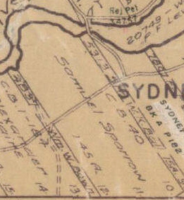
SYDNEY RIVER
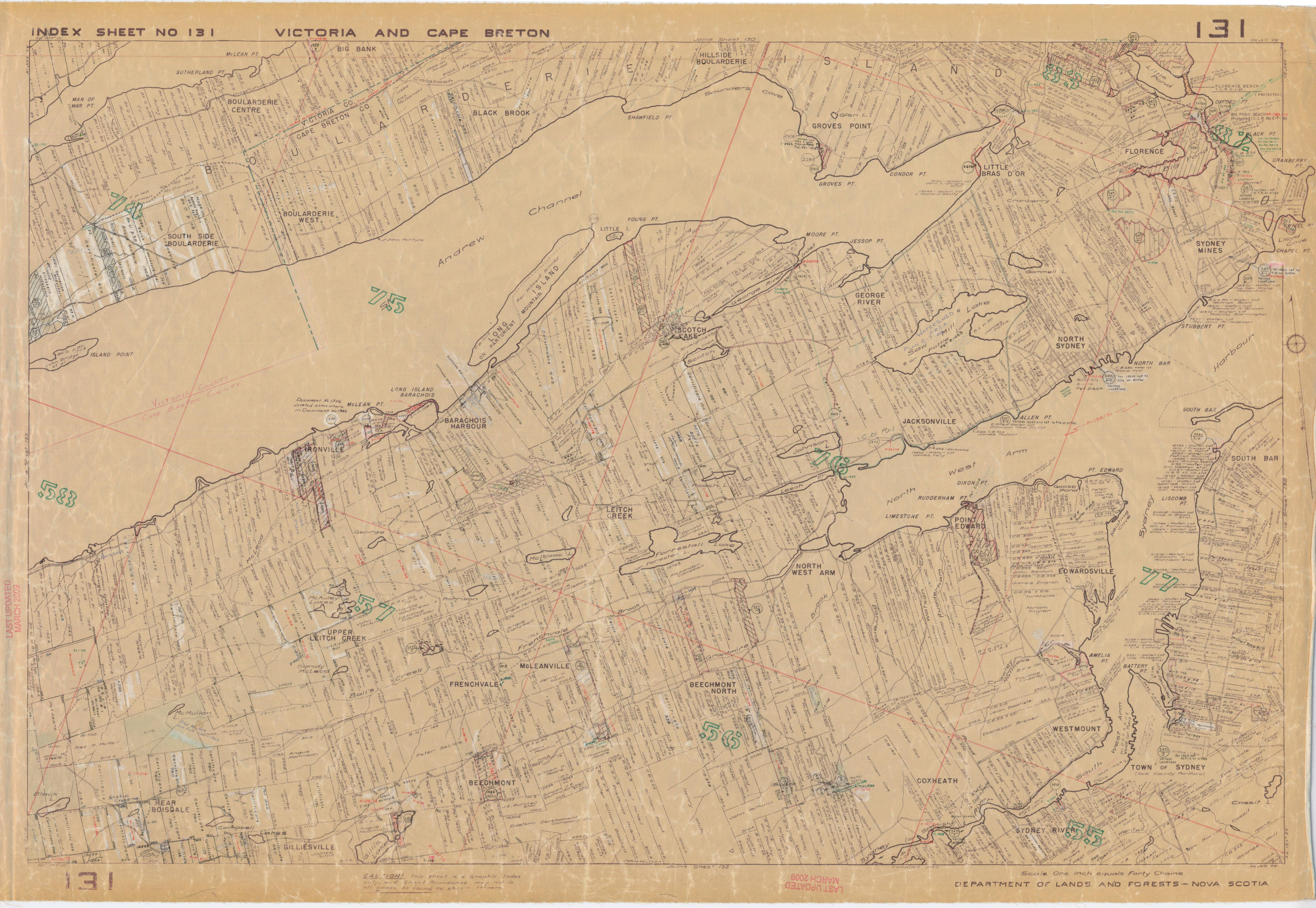
"INDEX SHEET NO 131 VICTORIA AND CAPE BRETON COUNTIES 131"
"SYDNEY RIVER"
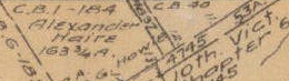
"C.B. 40
Samuel Sparrow
45 R"
Nova Scotia Index Sheet Map #131
https://novascotia.ca/natr/land/indexmaps/131.pdf
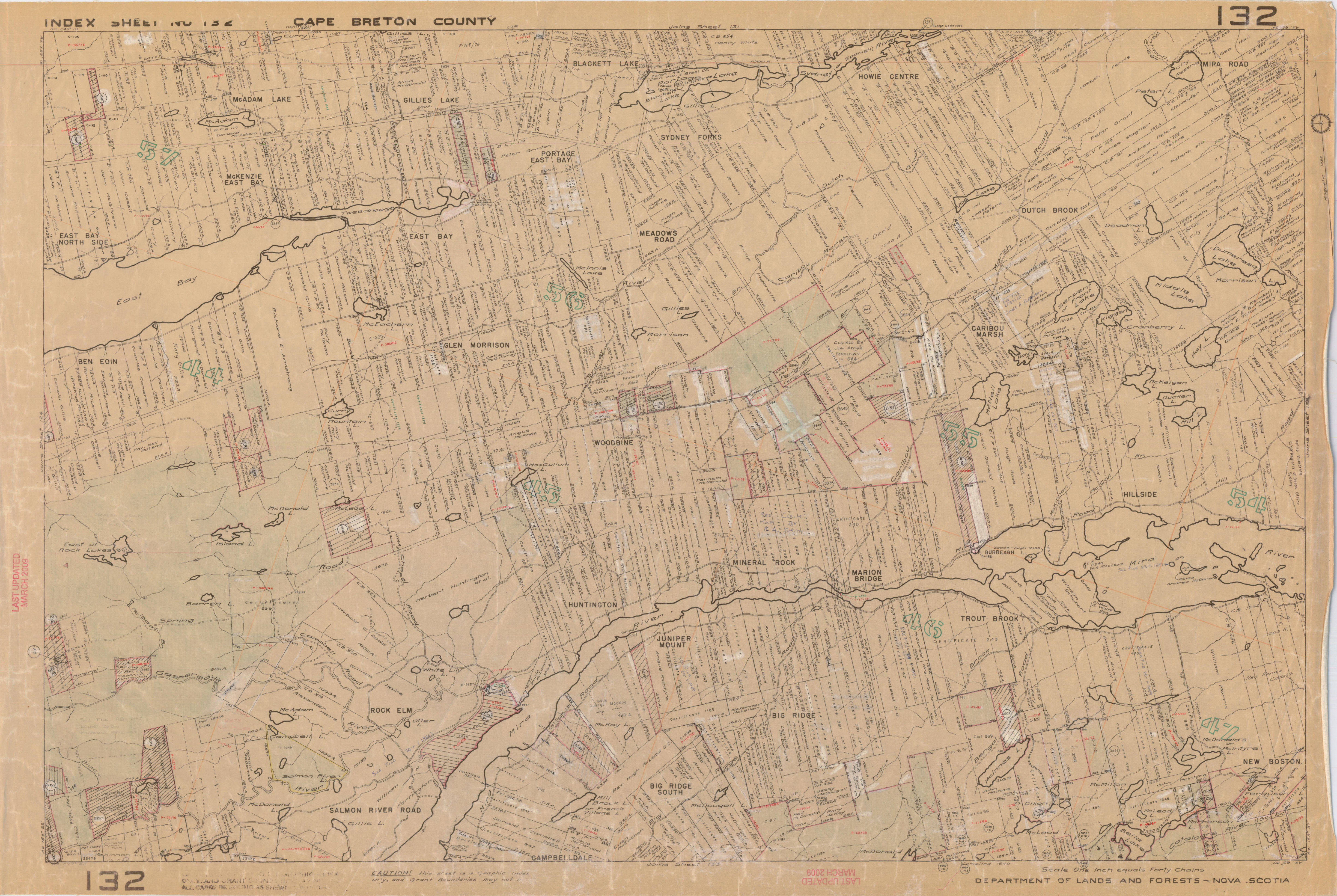
"INDEX SHEET NO 132 CAPE BRETON CO 132"
"C.B. 40"
Nova Scotia Index Sheet Map #132
https://novascotia.ca/natr/land/indexmaps/132.pdf
https://novascotia.ca/natr/land/grantmap.asp - Crown Land Records
(3) CHRONOLOGY
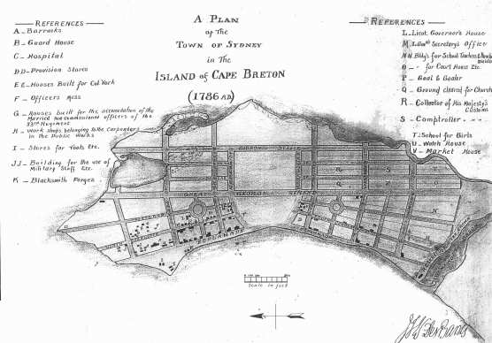
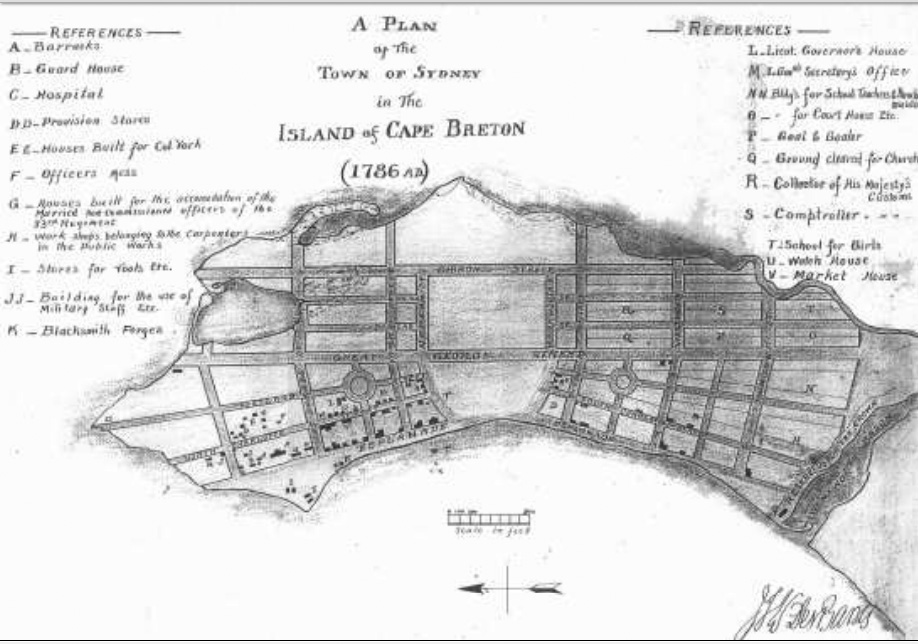
1786
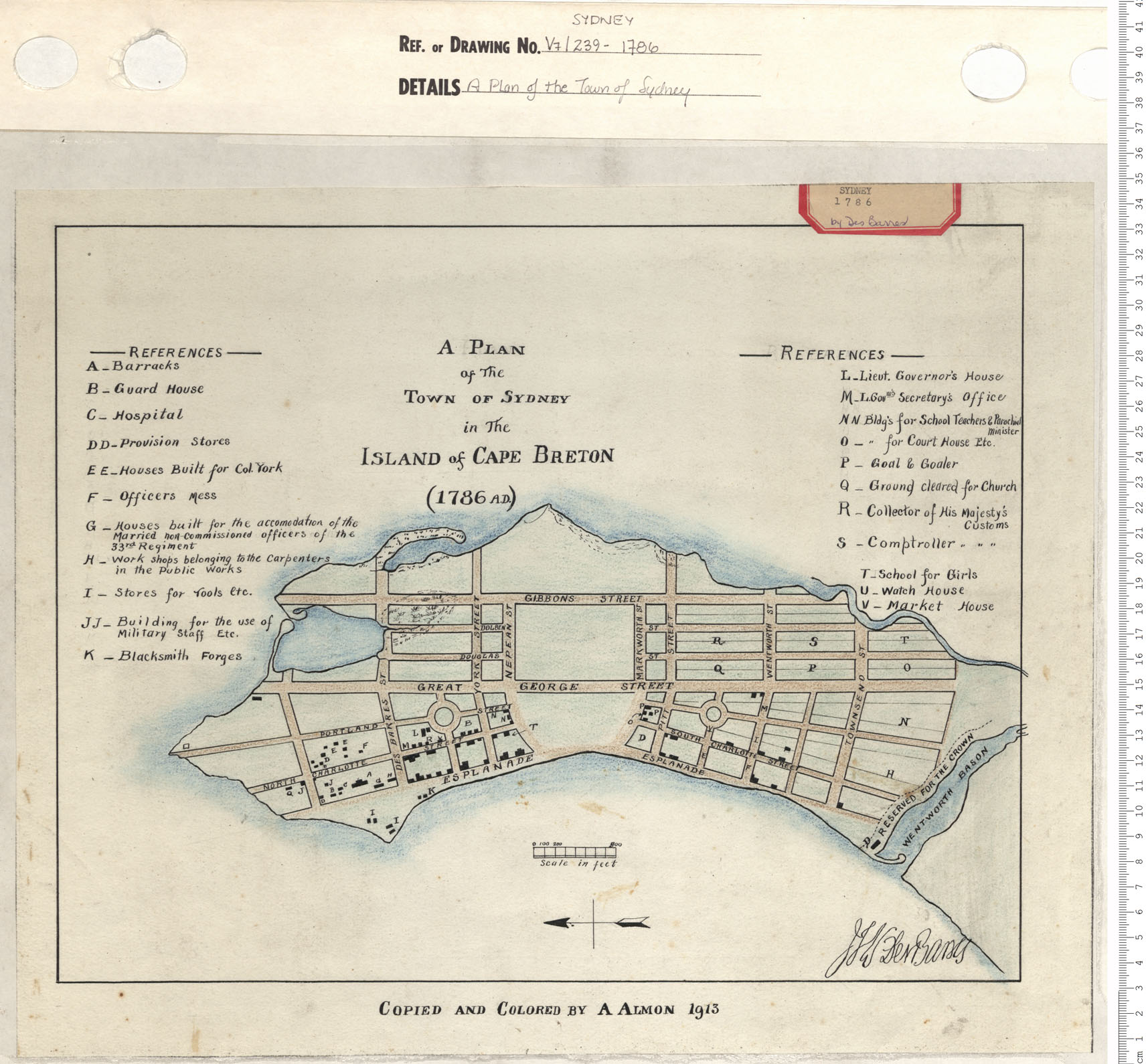
"A PLAN of The TOWN OF SYDNEY in The ISLAND of CAPE BRETON (1786 A.D.)"
[Signed] "JFW DesBarres"
"COPIED AND COLORED BY A ALMON 1913"
Date: 1786 Reference: Nova Scotia Archives Map Collection: V7 239 Sydney, Nova Scotia
https://archives.novascotia.ca/maps/archives/?ID=194
------------------------------------------------------
A PLAN of The TOWN OF SYDNEY in The ISLAND of CAPE BRETON (1786 A.D.)
[Signed JFW DesBarres]
A Plan of the Town of Sydney in the Island of Cape Breton, 1786 A.D. Copied in 1913 from J. W. F. DesBarres' map (1785)
1786 A Plan of the Town of Sydney in the Island of Cape Breton. By J. W. F. DesBarres; Lieutenant Governor, Cape Breton. Copied and colored by Albert Almon, 1913. [PANS V7/239-1786 - See also: PANS V7/239-1790, DesBarres plan copied in 1913 by Almon]
ftp://142.176.49.195/EIS/VOL1-09-AppendixG-N.pdf
------------------------------------------------------
http://www.tarpondscleanup.ca/upload/reports/VOL1-09-AppendixG-N.pdf
NOT DATED
[1786]
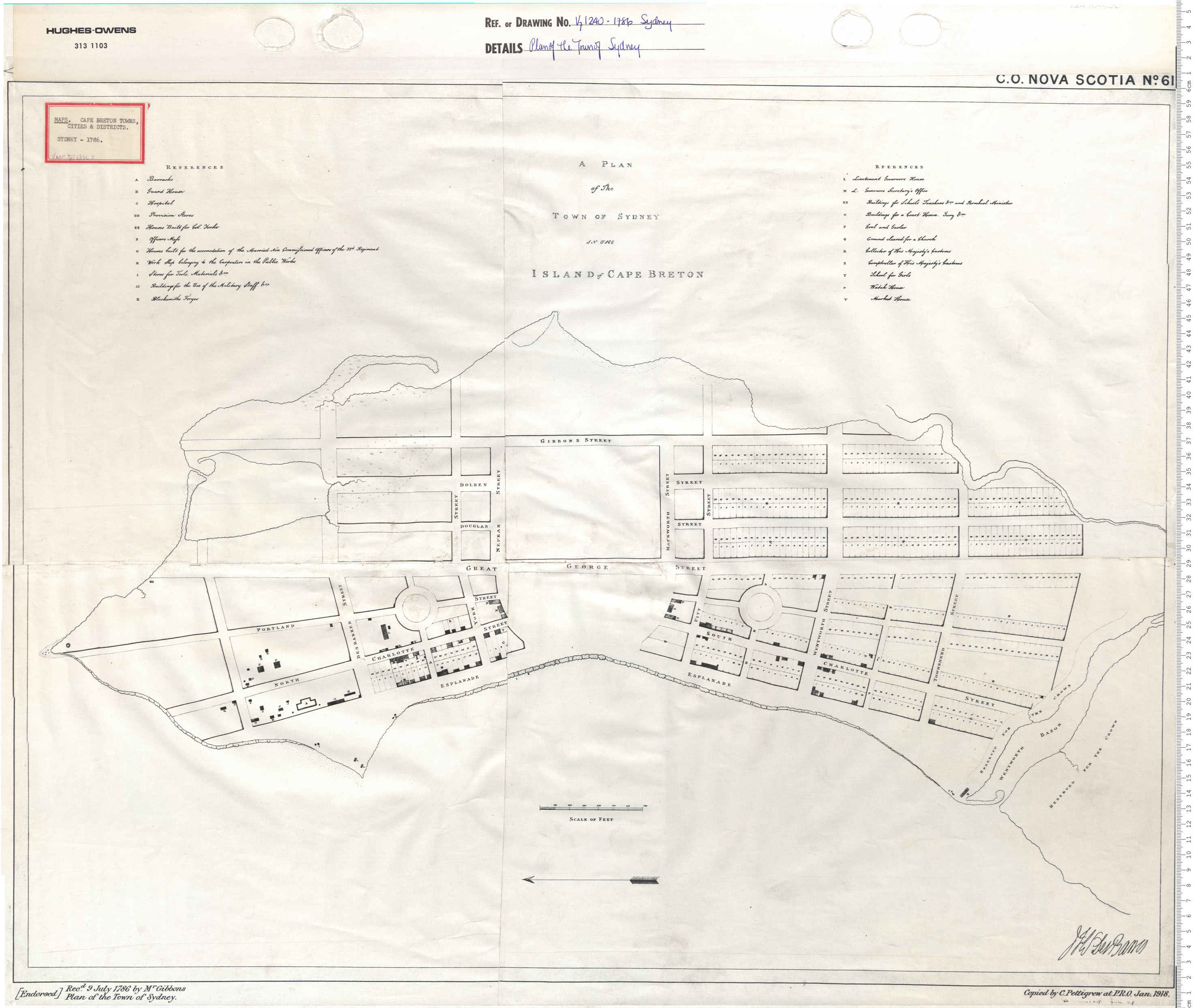
"A PLAN of The TOWN OF SYDNEY IN THE ISLAND of CAPE BRETON"
[Signed] "JFW DesBarres"
"Copied by C. Pettigrew at P.R.O. Jan. 1918."
Date: 1786 Reference: Nova Scotia
Archives Map Collection: V7 239 Sydney, Nova Scotia
C.O. NOVA SCOTIA No. 61
https://archives.novascotia.ca/maps/archives/?ID=194&Page=201402258
------------------------------------------------------
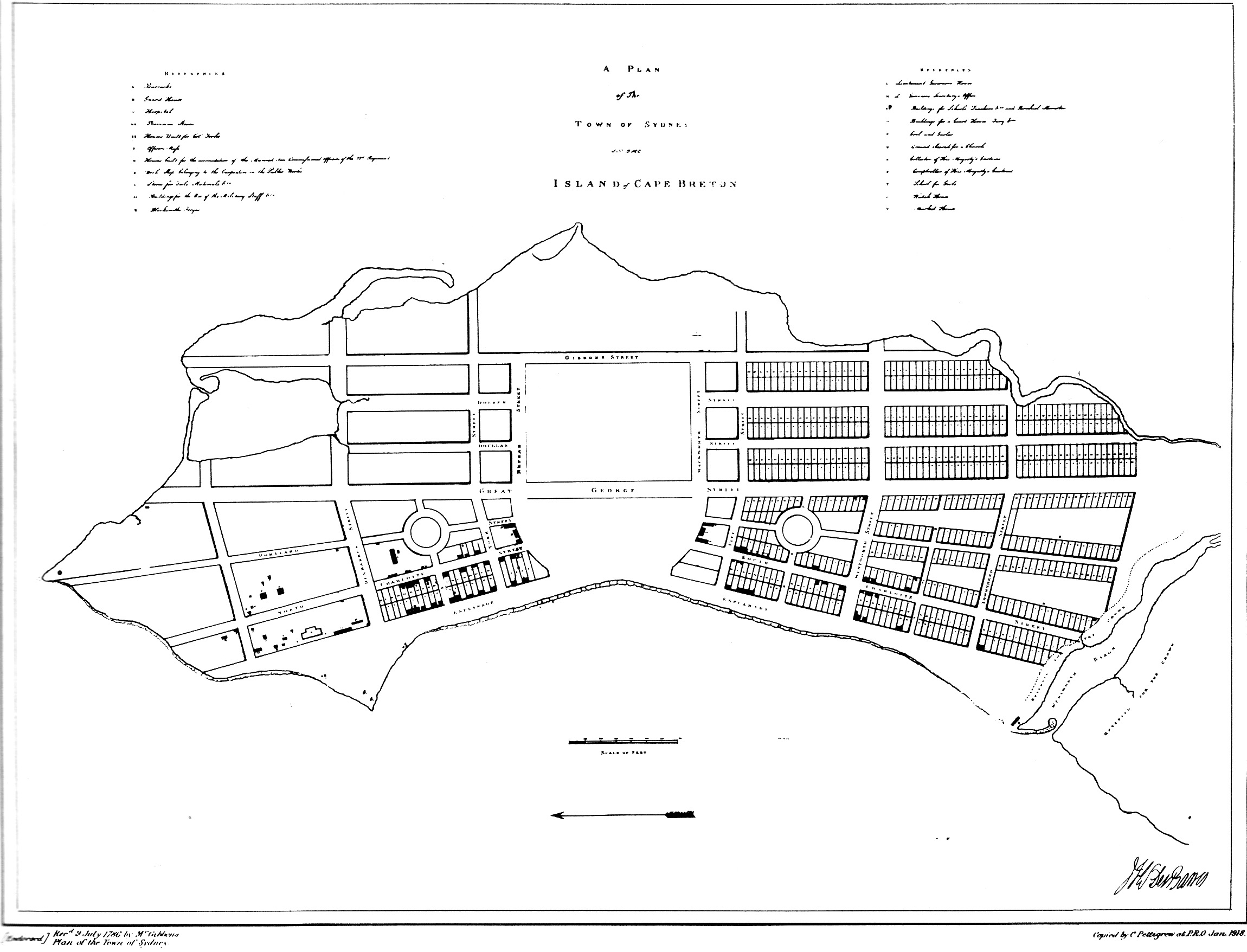
Recd 9 July 1786 by Mr Gibbons Plan of the Town of Sydney
C.O., Nova Scotia, No. 61 as Reproduced in Debra McNabb, Old Sydney Town, Historic Buildings of the North End (Sydney: Old Sydney Society, 1986), p. 11
1786, July 9 - A PLAN of The TOWN OF SYDNEY IN THE ISLAND OF CAPE BRETON C.O. Nova Scotia No. 61 by DESBARRES - "Recd. 9 July 1786 by Mr. Gibbons PLAN of the Town of Sydney" - Copied by C. Pettigrew at PRO, Jan, 1918 (PANS, V7, 1240-1786)
A PLAN of The TOWN OF SYDNEY IN THE ISLAND OF CAPE BRETON C.O. Nova Scotia No. 61 by DESBARRES
Copied by C. Pettigrew at PRO, Jan, 1918.
"Recd. 9 July 1786 by Mr. Gibbons PLAN of the Town of Sydney"
Shows a square building at 54 Charlotte Street (Corner of Amelia Street and Charlotte Street) on lot 27 with at least an equal amount of land remaining behind it. The building fronts lot 27 on Charlotte Street in its entirity
[Source: PANS, V7, 1240-1786]
FURTHER 1786 RESEARCH (ANY OF THESE NEW?)
1786, July 20 - Town plan of Sydney, Cape Breton Island, showing named streets and numbered reservations. Reference table distinguishes the lots laid out by five different surveyors. Scale: 1 inch to about 260 feet. Compass indicator. Surveyed by George Rodgers, Assistant Surveyor for Cape Breton and Deputy Surveyor General of Woods, on the order of Lieutenant Governor Des Barres, 20 July 1786 (London, Public Record office, Maps and plans extracted to flat storage from records of the Treasury and Treasury Solicitor 1670-1920, MPD 1/180/2)
------------------------------------------------------
1355. Sydney. 1786 Town plan by George Rogers, Assistant Surveyor for Cape Breton and Deputy Surveyor General of Woods etc., done by order of Lt. Govr. Des Barres, 20 July 1786. Named streets, numbered reservations, MS., coloured. About ... Maps and Plans in the Public Record Office: America and West Indies, H.M. Stationery Office, 1967 - Maps, p. 231. CO 700 Nova Scotia No 50?
------------------------------------------------------
1790 A Plan of the Town of Sydney in the Island of Cape Breton. J. W. F. DesBarres; Lieutenant Governor, Cape Breton. Copied and colored by Albert Almon, 1913. [PANS V7/239-1790]
------------------------------------------------------
1786 - Plan of the Town of Sydney in the Island of Cape Breton. By J. F. W. Des Barres, [Halifax]. MS. 250 feet to 1 inch.-(PANS, V7, 1239-1786 and National Archives, Kew, CO 700/NOVA SCOTIA61 - Plan of the Town of Sydney in the Island of Cape Breton. By J. F. W. Des Barres, [Halifax]. MS. 250 feet to 1 inch.)
[See: 1785 A Plan of the Town of Sydney in the Island of Cape Breton. By J. W. F. DesBarres; Lieutenant Governor, Cape Breton. [PANS 239-1785]]
------------------------------------------------------
1786 - Plan of the Town and Environs of Sydney. By J. F. W. Des Barres, [Halifax]. MS. 20 chains to 1 inch. - (National Archives, Kew, CO 700/NOVA SCOTIA65)
------------------------------------------------------
1357. Sydney. [1786] "A Plan of the Town in the Island of Cape Breton." Signed "J. F. W. Des Barres." MS., coloured. About 260 ft. to an inch. Two reference tables. Compas indicator. 2 ft. 9 in. x 2 ft. 1 in. Similar to 1355, though Rogers name does not appear. Maps and Plans in the Public Record Office: America and West Indies, H.M. Stationery Office, 1967 - Maps, p. 232. CO 700 Nova Scotia No 61?
NOT DATED
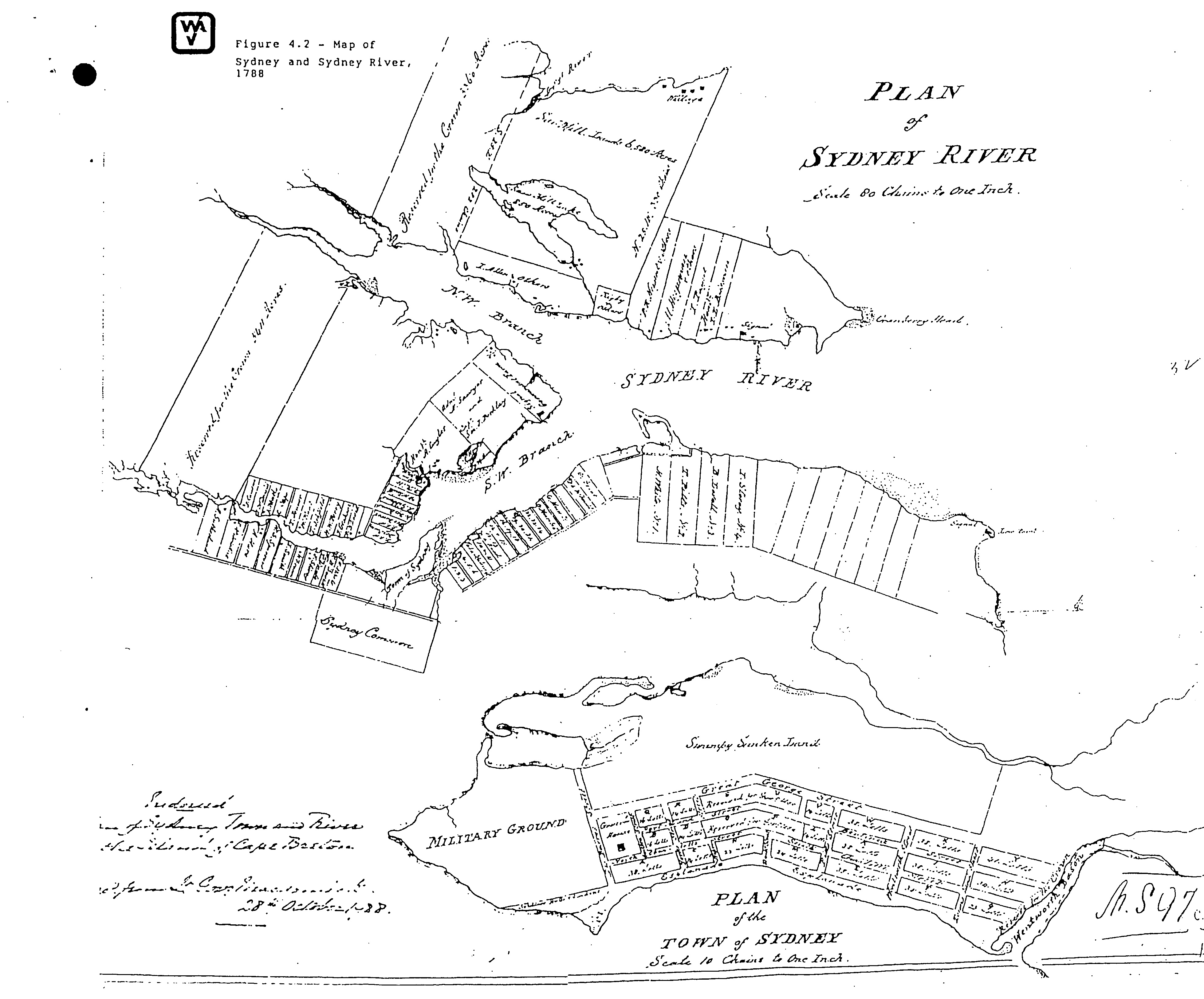
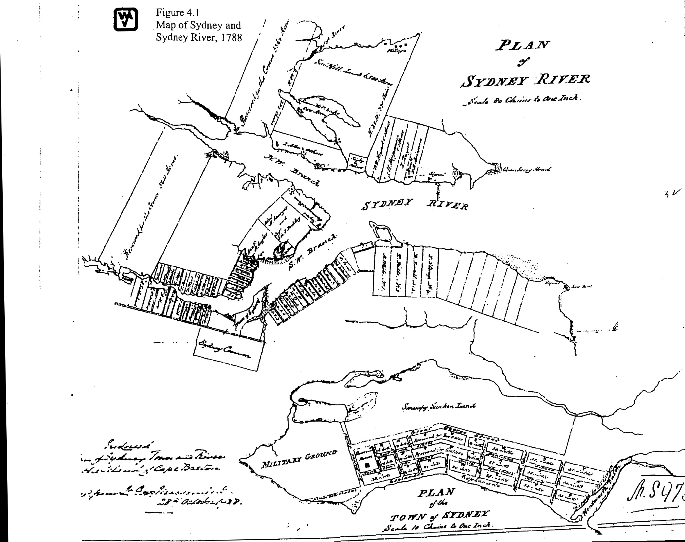
[1788]
JPEGS
"PLAN of
SYDNEY RIVER Scale 80 Chains to One Inch"
"PLAN of the TOWN of SYDNEY Scale 10
Chains to One Inch"
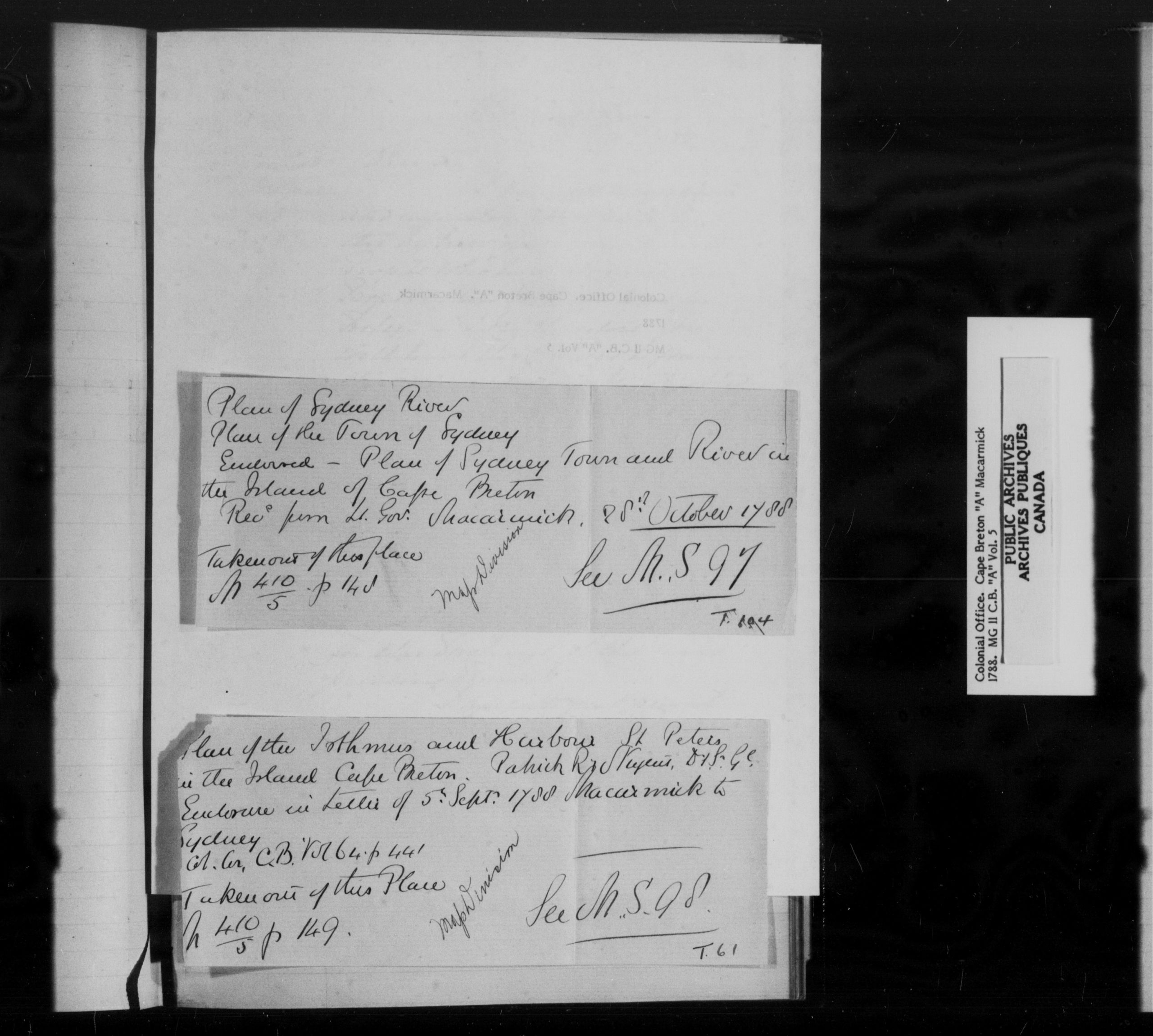
"
Enclosed - Plan of Sydney Town and River on the Island of Cape Breton
Recd from Lt. Gov. Macarmick. 28th October 1788"
"N.S. 97"
1788, October 28 - Plan of Sydney Harbour, and Plan of the Town of Sydney (N.S. 97 C.B. T 14 - Beaton Institute)
http://www.ceaa.gc.ca/050/documents_staticpost/cearref_8989/JWEL-12.pdf
http://www.ceaa.gc.ca/050/documents_staticpost/cearref_8989/JWEL-17.pdf
------------------------------------------------------
"PLAN of SYDNEY RIVER Scale 80 Chains to One Inch"
ftp://142.176.49.195/EIS/VOL1-09-AppendixG-N.pdf
------------------------------------------------------
Before September 5, 1788
C-11530
"Plan of
Sydney River
Plan of the Town of Sydney
Enclosed - Plan of Sydney Town and River on
the Island of Cape Breton
Recd from Lt. Gov. Macarmick. 28th October 1788
Taken out of this place
N 410/5 p 148
See N.S. 97
T. 104"
Enclosed in a
Macarmick Letter of September 5, 1788 to Lord Sydney,
and received October 28, 1788 and subsequently removed to the Map Division, See
N.S. 97 / T 140
Colonial Office, Cape Breton, "A" Macarmick 1788, MG 11 C.B. "A" Vol. 5, p. [147]
Col. Cor. C.B. Vol. 54. p. 411
http://heritage.canadiana.ca/view/oocihm.lac_reel_c11530/1095?r=0&s=6
http://heritage.canadiana.ca/view/oocihm.lac_reel_c11530/1?r=0&s=6
------------------------------------------------------
See Also the
Calendar at:
Annual Report - Public Archives of Canada By Public Archives of Canada - State
Papers -
Cape Breton Public Archives of Canada, 1896, p. 20
------------------------------------------------------
Plan of Sydney River. Enclosed in letter
of 5 Sept., 1788. Endorsed. Plan of Sydney Town and River in the Island of Cape
Breton. Recd. from Lt. Govr. Macarmick, 28th October, 1788,
Scale of River, 80 chains=1 inch.
Scale of Town, 10 chains, =1 inch. 21 x 19.
------------------------------------------------------
Catalogue of Maps, Plans and Charts in the Map Room of the Dominion Archives, By H. R. Holmden, Public Archives of Canada, 1912, p. 399
NOT DATED
[c. 1790]
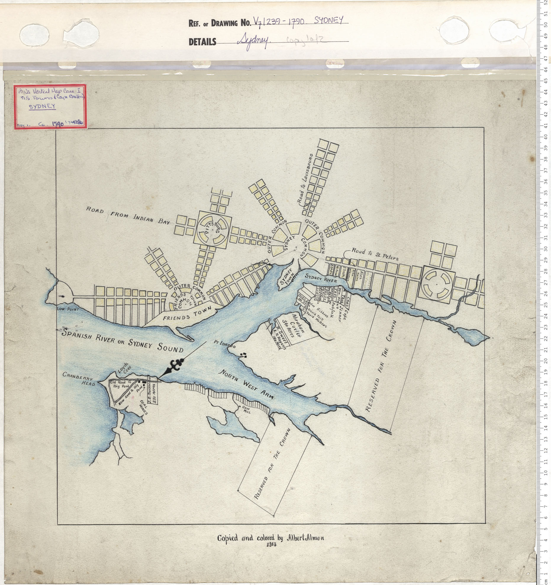
[NO TITLE]
"Copied and colored by Albert Almon 1913"
Date: 1790 Reference: Nova Scotia Archives Map Collection: V7 239 Sydney, Nova Scotia
https://archives.novascotia.ca/maps/archives/?ID=204
------------------------------------------------------
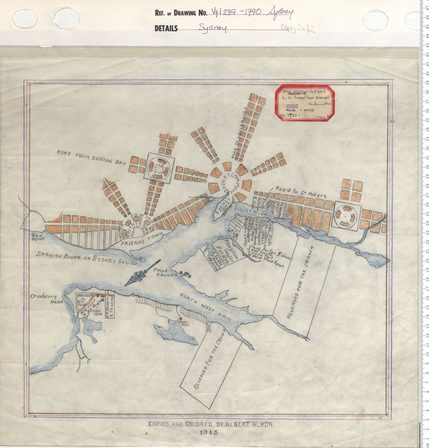
[NO TITLE]
"COPIED AND COLORED BY ALBERT ALMON 1913"
Date: 1790 Reference: Nova Scotia Archives Map Collection: V7 239 Sydney, Nova Scotia
https://archives.novascotia.ca/maps/archives/?ID=204&Page=201402260
1792
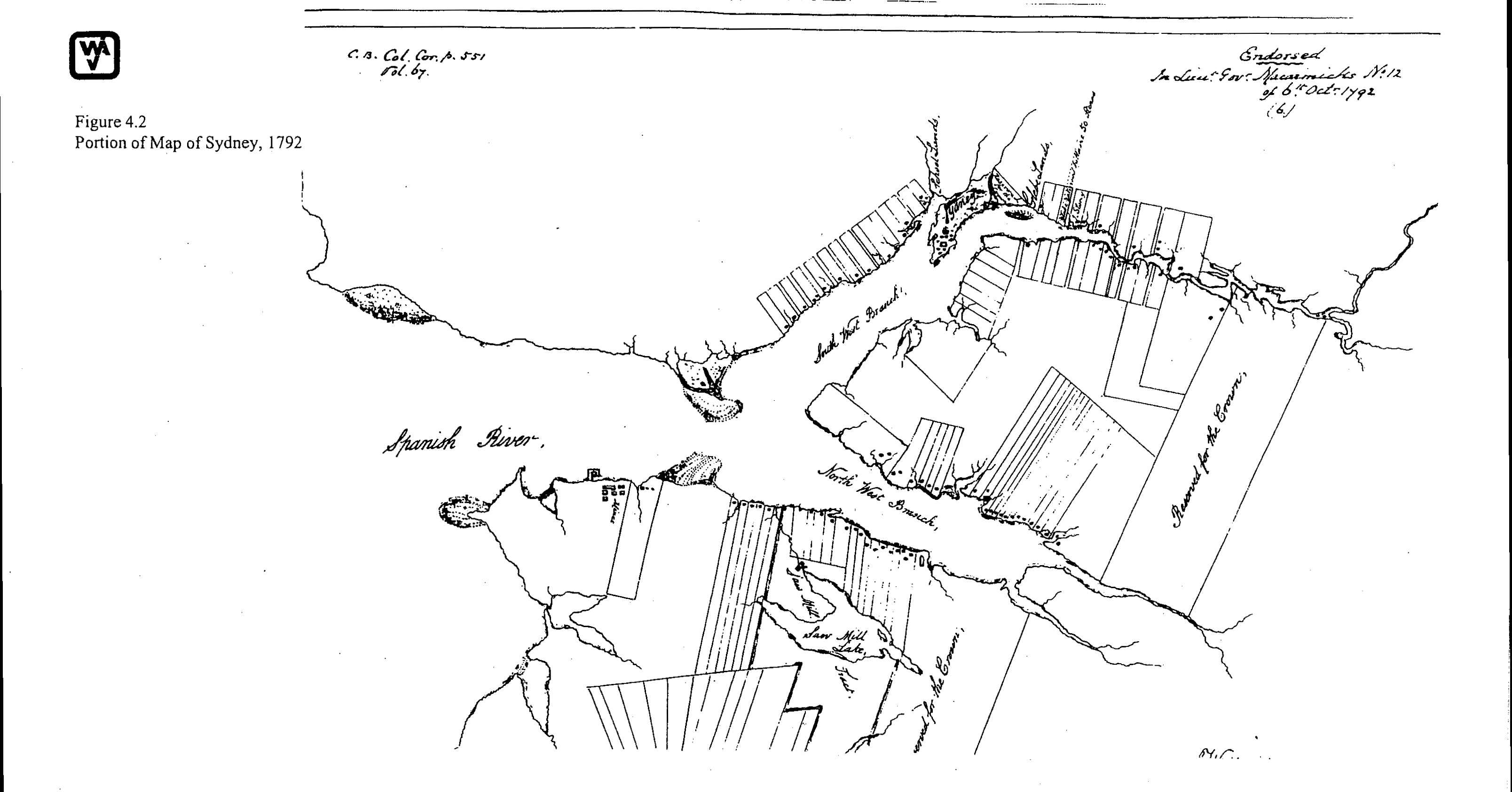
Larger Portion of the Plan
"Endorsed
In Lieut Govr. Macarmicks No. 12
of 6 th. Octr. 1792
(6.)"
"C.B. Col. Cor. p. 551 Vol. 67"
Extract
JPEG
1792 - A Plan of the Two Branches of Spanish River, with the Town of Sydney, and Settlements adjacent. By William Cox; Acting Surveyor General of Lands, Cape Breton. [PANS 239-1792]
http://www.ceaa.gc.ca/050/documents_staticpost/cearref_8989/JWEL-12.pdf
http://www.ceaa.gc.ca/050/documents_staticpost/cearref_8989/JWEL-17.pdf
1794
 |
|
 |
|
JPEGS
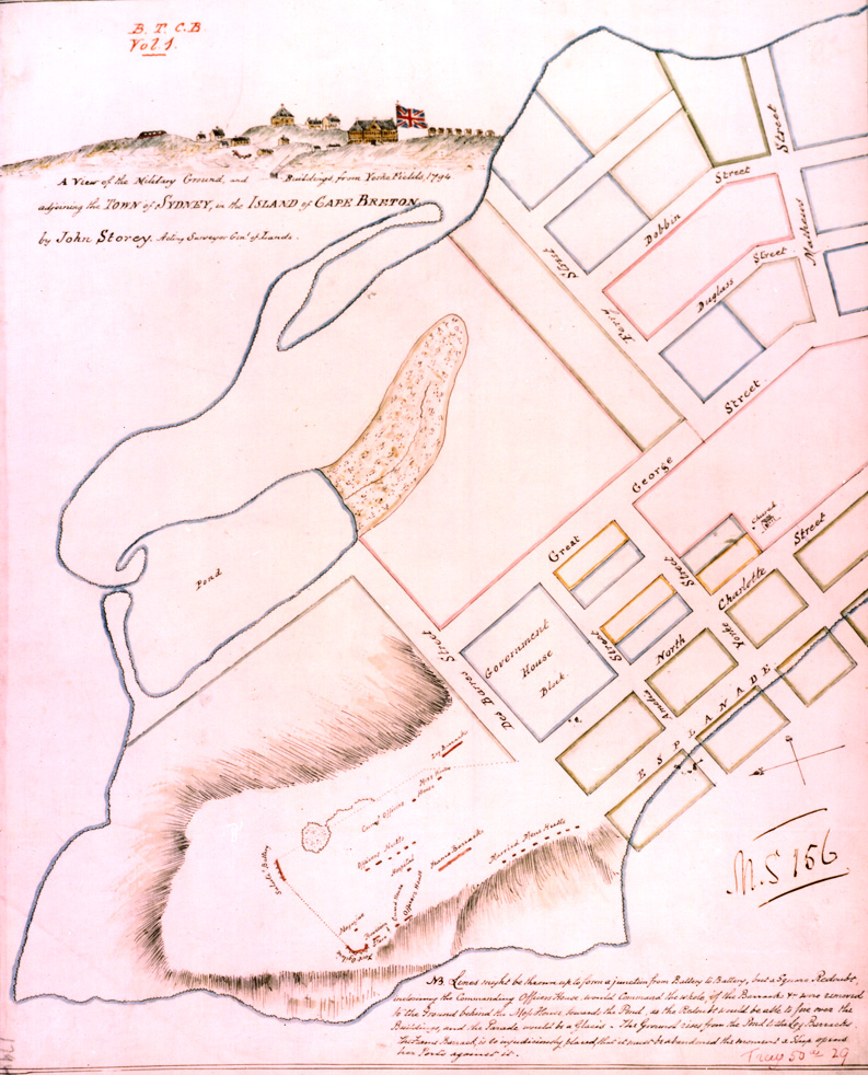
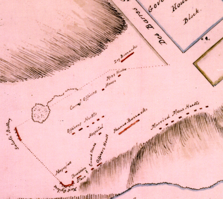
"A View of the Military Ground, and Buildings
from Yorke Fields, 1794, adjoining the TOWN of SYDNEY, in the ISLAND of
CAPE BRETON, by John Storey. Acting Surveyor Genl. of Lands."
" B.T.C.B. Vol. 1"
"M.S 156"
"Tray 50th 29"
"C3344 1794"
Maps © Library and
Archives of Canada -
National Archives (Kew), MPI 1/342,
BT 6/35 (folios 427-428)
Source of the ©Doug Storey
coloured versions:
http://www.cb-ns.org/1794-Sydney.html
[Doug Storey: "By
1789 John Storey was Sydney's first Postmaster. A former postmaster confirms
this in an article written in the Halifax Herald in 1885. William Blackburn
and John Storey are named as merchants who in December 1790 bought lot A in
Block 27. Today this is 54 Charlotte Street in Sydney."]
1794 - A View of the Military Ground, and Buildings from Yorke Fields, 1794, adjoining the Town of Sydney, in the Island of Cape Breton. Drawn by John Storey, Acting Surveyor of Lands - (B.T.C.B. Vol. 1 - Tray 50 ... 29, C3344 1794 - Beaton Institute)
1794
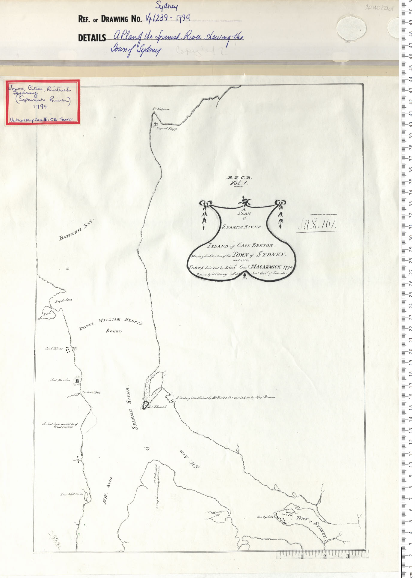
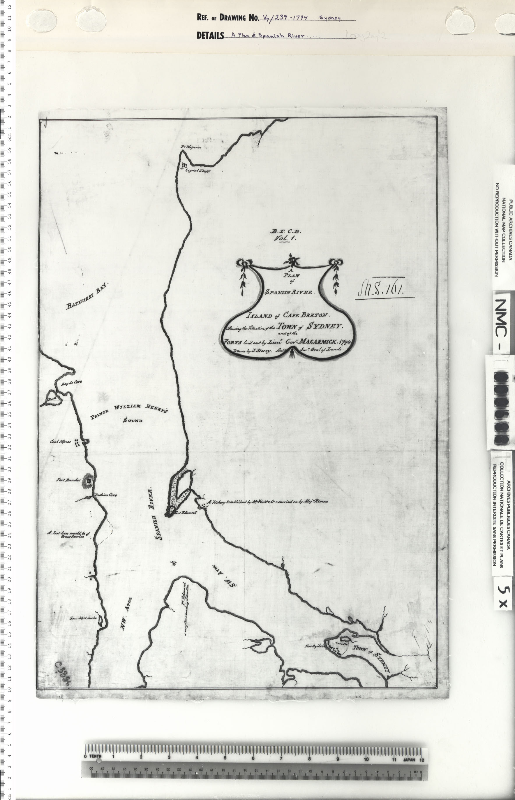
"A PLAN of SPANISH RIVER
ISLAND of CAPE BRETON.
Shewing the Situation of the TOWN of SYDNEY.
and of the
FORTS laid out by Lieut Govr . MACARMICK. 1794.
Drawn by J. Storey. Act. Surv. Genr. of Lands."
"B.T.C.B.
Vol. 1."
"N.S. 101."
Date: 1794 Reference: Nova Scotia Archives Map Collection: V7 239 Sydney, Nova Scotia
https://archives.novascotia.ca/maps/archives/?ID=215
------------------------------------------------------
"A PLAN of SPANISH RIVER
ISLAND of CAPE BRETON.
Shewing the Situation of the TOWN of SYDNEY.
and of the
FORTS laid out by Lieut Govr . MACARMICK. 1794.
Drawn by J. Storey. Act. Surv. Genr. of Lands."
"B.T.C.B.
Vol. 1."
"N.S. 101."
Date: 1794 Reference: Nova Scotia Archives Map Collection: V7 239 Sydney, Nova Scotia
https://archives.novascotia.ca/maps/archives/?ID=215&Page=201402262
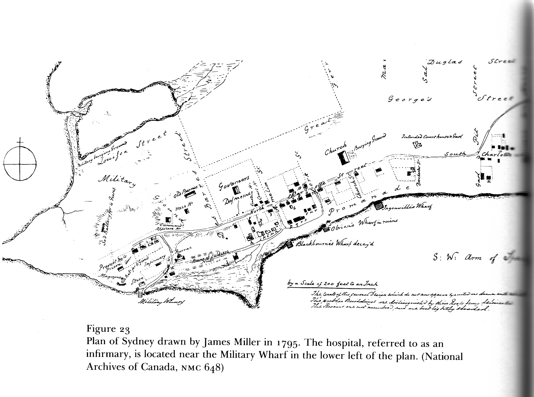
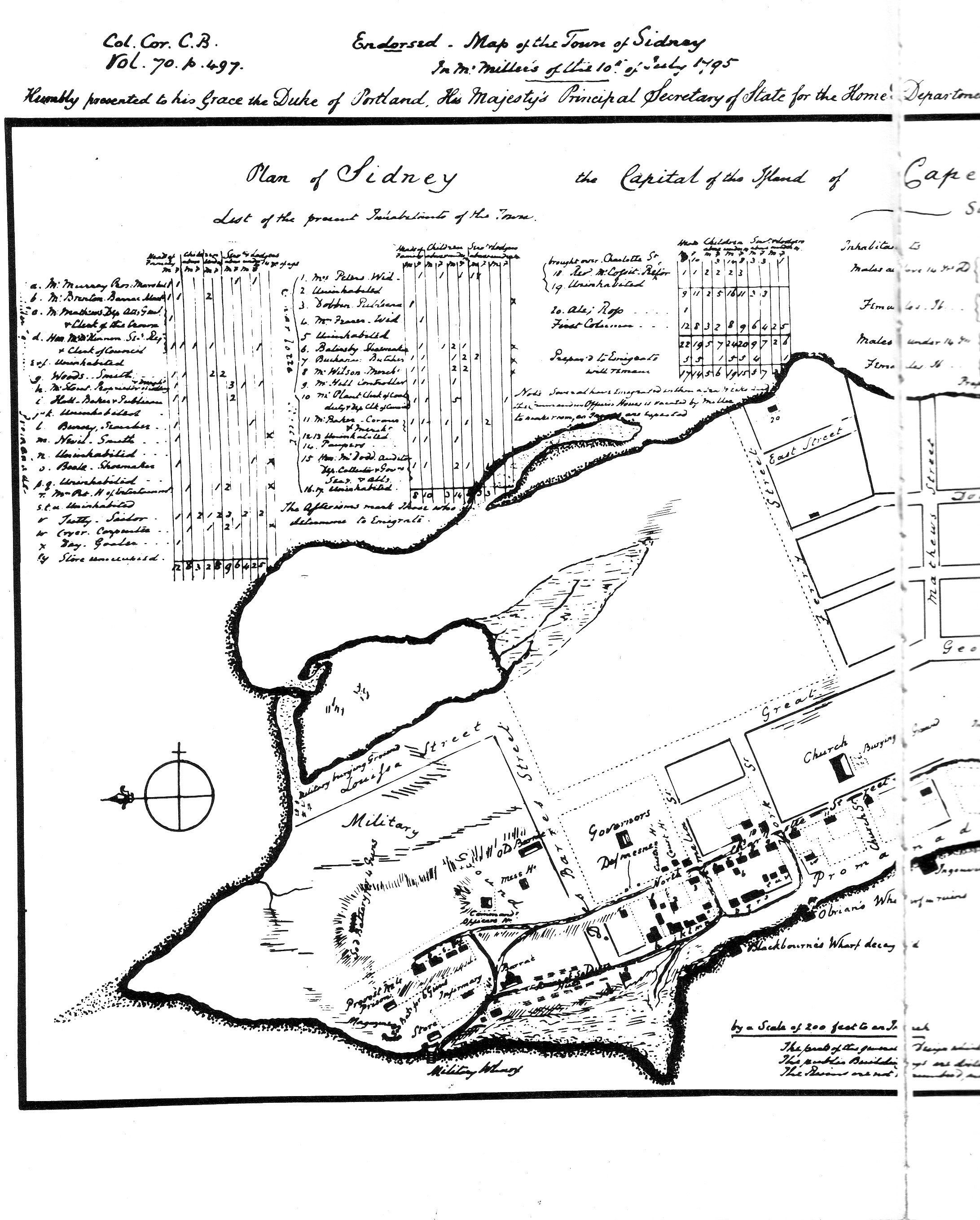
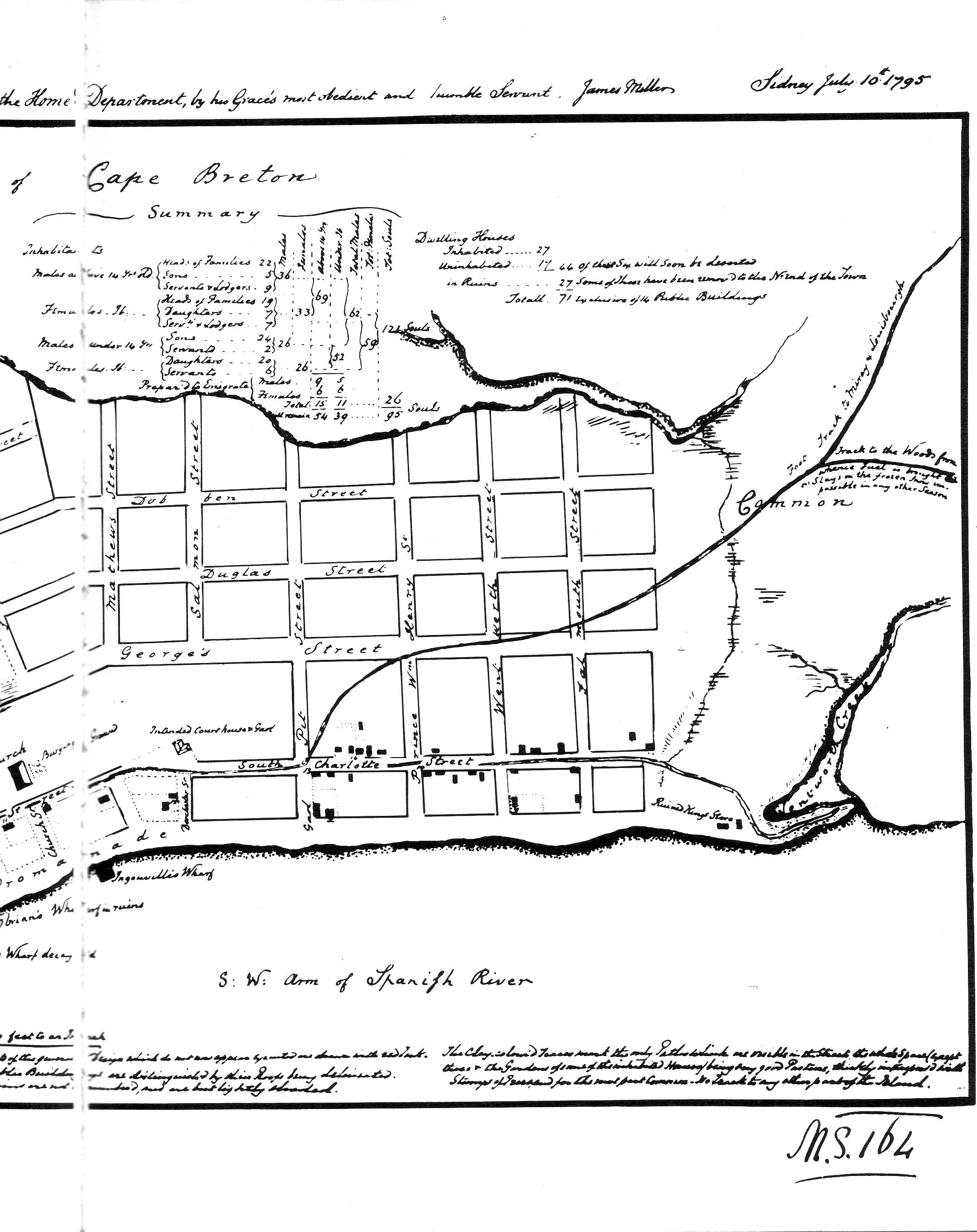
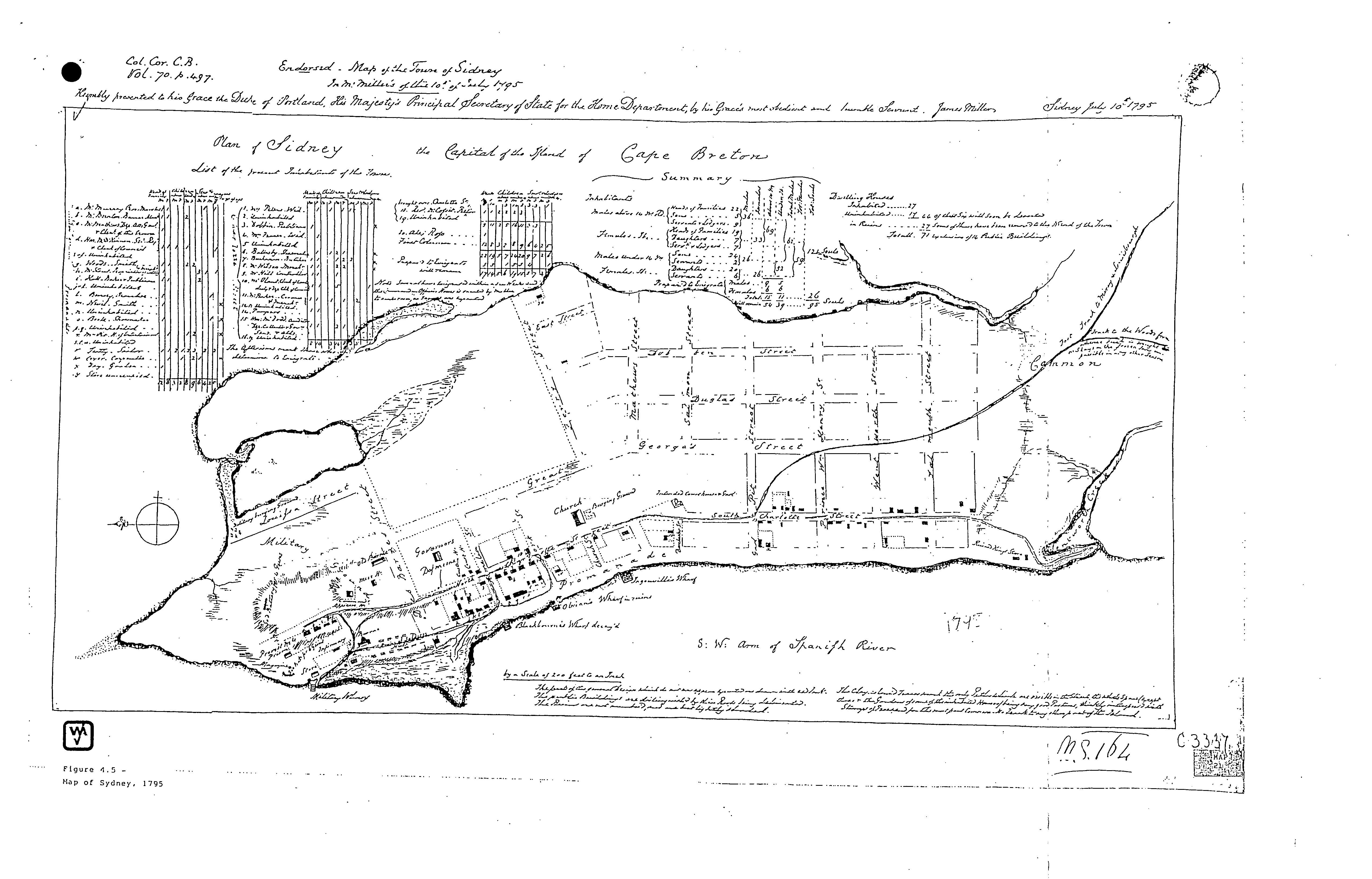
1795
"Plan of Sidney the Capital of the Island of Cape Breton"
"List of the present Inhabitants of the Town" "Summary"
"Endorsed. Map of the Town of Sidney
In Mr. Miller's of this 10.th of July 1795"
"Kindly presented to his
Grace
the Duke of Portland, His Majesty's Principal Secretary of State for the
Home Department, by his Grace's most obedient and humble Servant. James
Miller Sidney July 10.th 1795"
"Col. Cor. C.B. Vol. 70. p. 497."
"N.S. 164 "
Date: 1795 Reference: Nova Scotia Archives Map Collection: V7 239 Sydney, Nova Scotia
https://archives.novascotia.ca/maps/archives/?ID=220
------------------------------------------------------
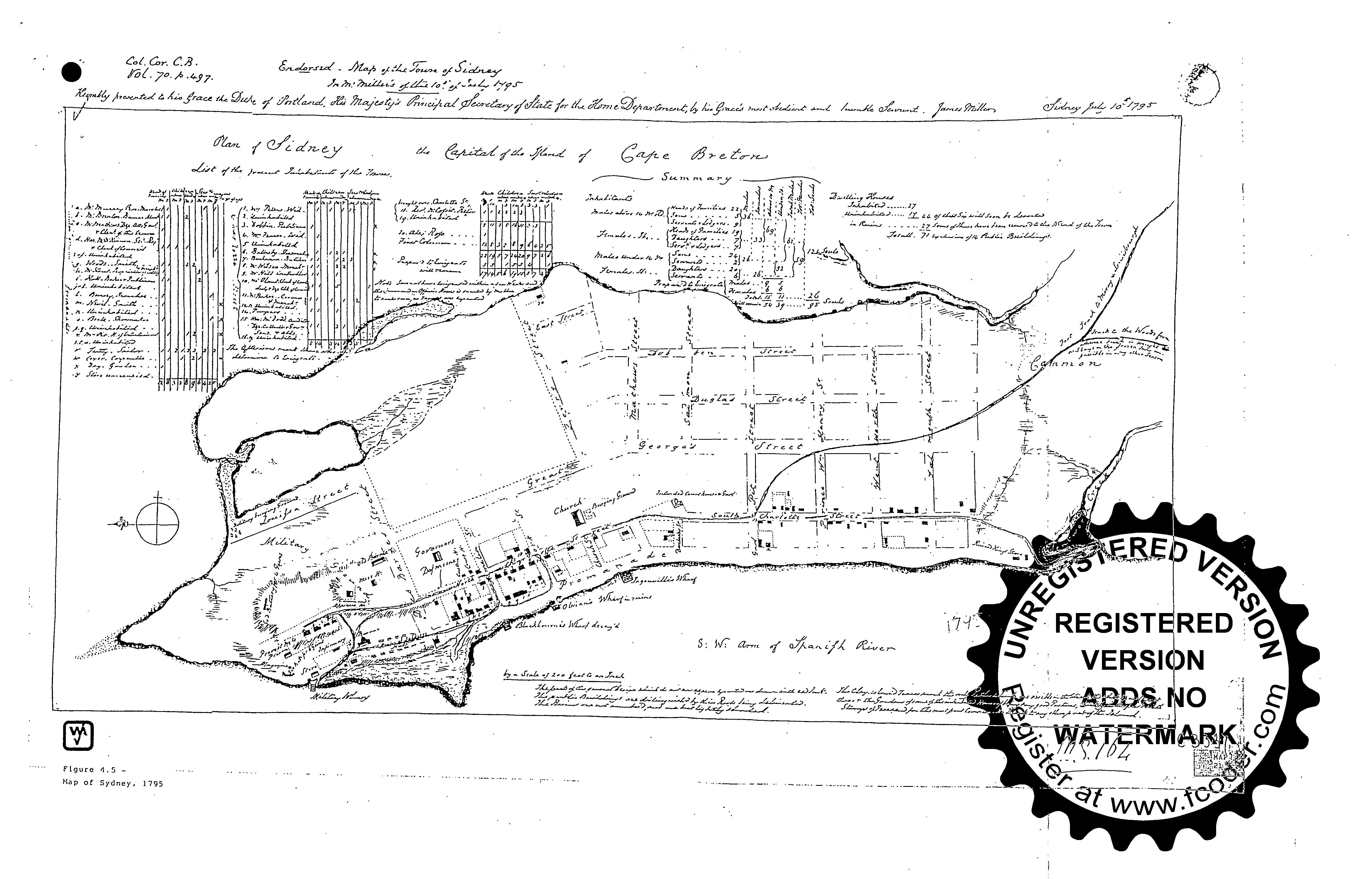
Entire Plan
JPEG

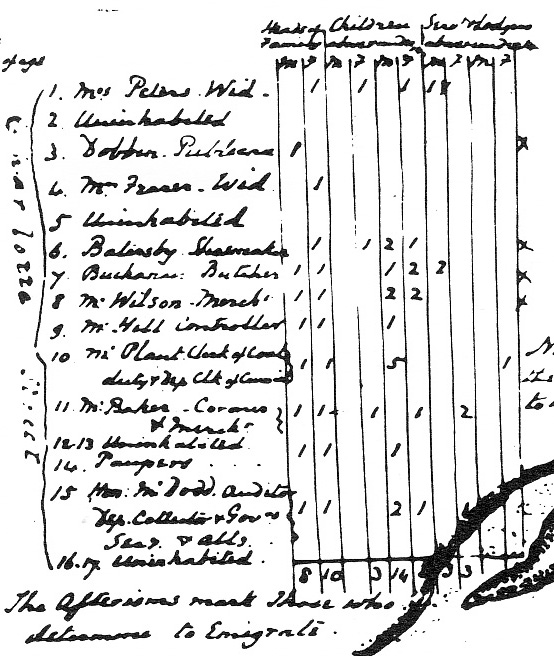
List of the present Inhabitants of the Town
Charlotte Street
4. = Mr. Fraser. Irish
[Sparrow sold
the land and a dwelling to Colin Fraser, a disbanded Loyalist soldier, on
September 17, 1787. Colin Fraser's will is dated December 13, 1787. Colin and,
later alone, Christian, his wife, owned the property from September 17, 1787 to
December 30, 1790. Fraser sold the property to the merchants, William Blackburn
and John Storey, on December 30, 1790. Peter Grant, Yeoman and his wife, Sarah,
sold the property to Thomas Samuel Bown on July 26, 1824. Bown was the agent of
the English merchants, Thomas Anderton and Samuel Woods, of Liverpool.]
http://www.ceaa.gc.ca/050/documents_staticpost/cearref_8989/JWEL-12.pdf
http://www.ceaa.gc.ca/050/documents_staticpost/cearref_8989/JWEL-17.pdf
Col. Cor. C.B. Vol. 70, p. 497 Endorsed - Map of the Town of Sidney In Mr. Miller's of this 10.th of July 1795 - Kindly presented to his Grace the Duke of Portland, His Majesty's Principal Secretary of State for the Home Department, by his Grace's most obedient and humble Servant. James Miller Sidney July 10.th 1795 N.S. 164 [Reference - Beaton Institute]
------------------------------------------------------
 |
JPEG
Sydney 1795 - (From Allan Everett Marble, Surgeons, Smallpox and the Poor: A History of Medicine and Social Conditions in Nova Scotia, 1749-1799 (McGill-Queen's University Press, Montreal & Kingston, 1993) - PANS, CO 217, 111: 245)
------------------------------------------------------
JPEG
Col. Cor. C.B. Vol. 70. p. 497 Endorsed - Map of the Town of Sidney In Mr. Miller's of this 10.th of July 1795 - Kindly presented to his Grace the Duke of Portland, His Majesty's Principal Secretary of State for the Home Department, by his Grace's most obedient and humble Servant. James Miller Sidney July 10.th 1795 N.S. 164
C-11531 - Col. Cor. C.B, Vol. 70. p. 497, 1795, July 10th -
["Enclosed. Plan, with streets (those only proposed marked with red ink), inhabitants, etc."- Report on Canadian Archives, 1895, Public Archives of Canada, 1896 - State Papers, Cape Breton, p. 57]
Debra McNabb/Lewis Parker, Old Sydney Town, Historic Buildings of the North End (Sydney: Old Sydney Society, 1987), pp. 30-31 [Beaton Institute]
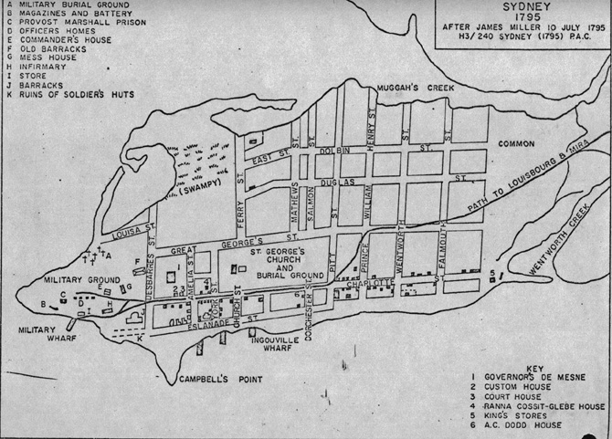
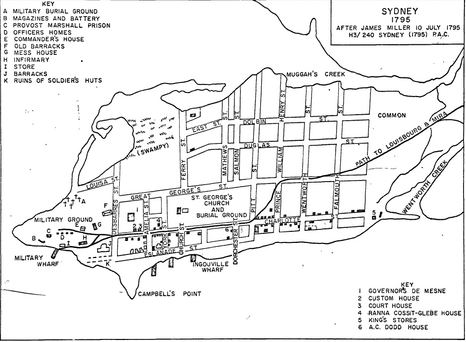
1795
JPEG
Sydney 1795 - (After National Archives of Canada, James Miller, July 10, 1795 H3/240 Sydney (1795) as redrawn in Robert J. Morgan, Orphan Outpost: Cape Breton Colony, 1784-1820 (Ottawa, University of Ottawa Ph.D. Thesis, June 1972)
NOT DATED
(AFTER 1812)
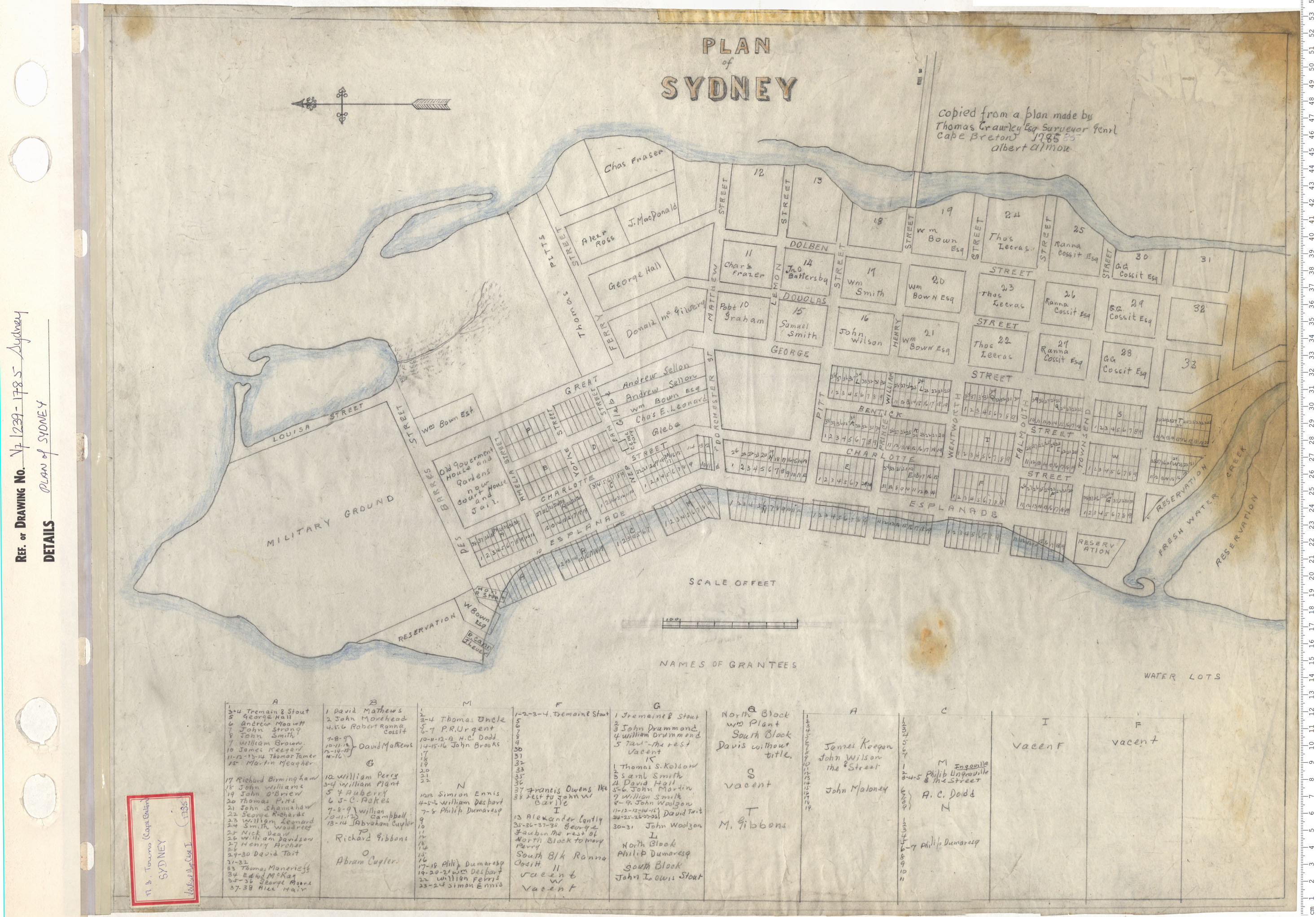
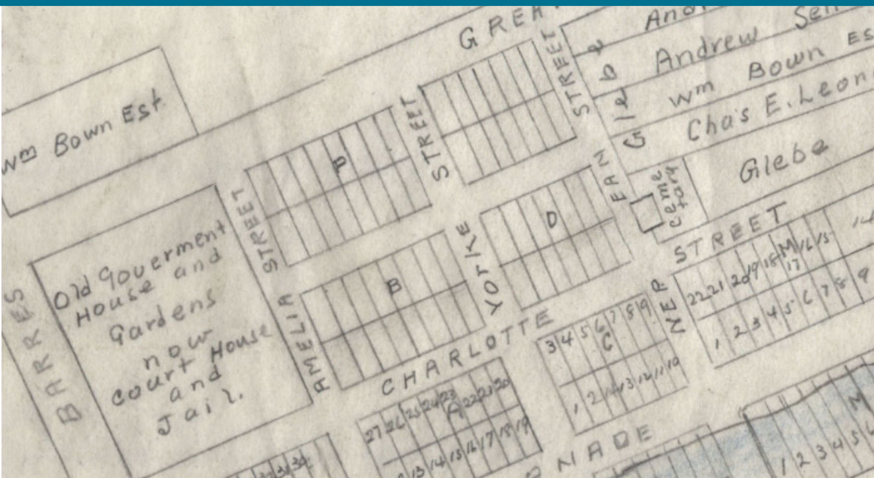
"PLAN of SYDNEY"
"Copied from a plan made by Thomas Crawley Esq Surveyor Genrl Cape Breton 1785 [Erased: ? 85] Albert Almon"
Date: 1785 Reference: Nova Scotia Archives Map Collection: V7 239 Sydney, Nova Scotia
https://archives.novascotia.ca/maps/archives/?ID=187
[In 1803, Crawley was appointed to the post of Surveyor-General of Cape Breton which later became known by the title of Surveyor of Lands in 1809. ... his major contributions to life in Cape Breton rested with his work as a surveyor. As a surveyor, he was responsible for dividing lots of land for settlers; preparing plans, descriptions, and affidavits; and completing the grants for purchased lands. Thomas Crawley retired as a surveyor in approximately 1834.
https://epe.lac-bac.gc.ca/100/205/301/ic/cdc/virtualtours/pecrawley.html
[Note: This plan might be the one copied by Thomas Crawley, but not in 1785, since he was not appointed Surveyor General until 1803 - Richard Brown, A History of the Island of Cape Breton with Some Account of the Discovery and Settlement of Canada, Nova Scotia, and Newfoundland (1869), p. 426.]
[Captain Thomas Crawley (1757-1851) came to Cape Breton about 1789. He served as Surveyor-General in Cape Breton and Superintendent of Mines - https://www.cbu.ca/wp-content/uploads/2019/08/beaton-aid-guide.pdf ]
["The city’s earliest courthouse was built in 1786 and stood on North Charlotte Street" https://courts.ns.ca/history_of_courts/history_noframes/courthouses.htm ] DesBarres produced a plan in 1786 - http://www.krausehouse.ca/krause/josthouse/1786SydneyCourtHouse.html]
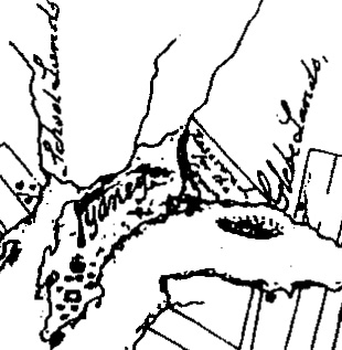
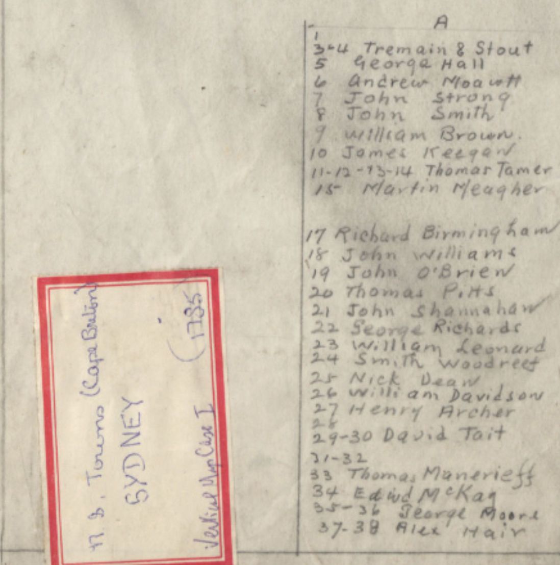
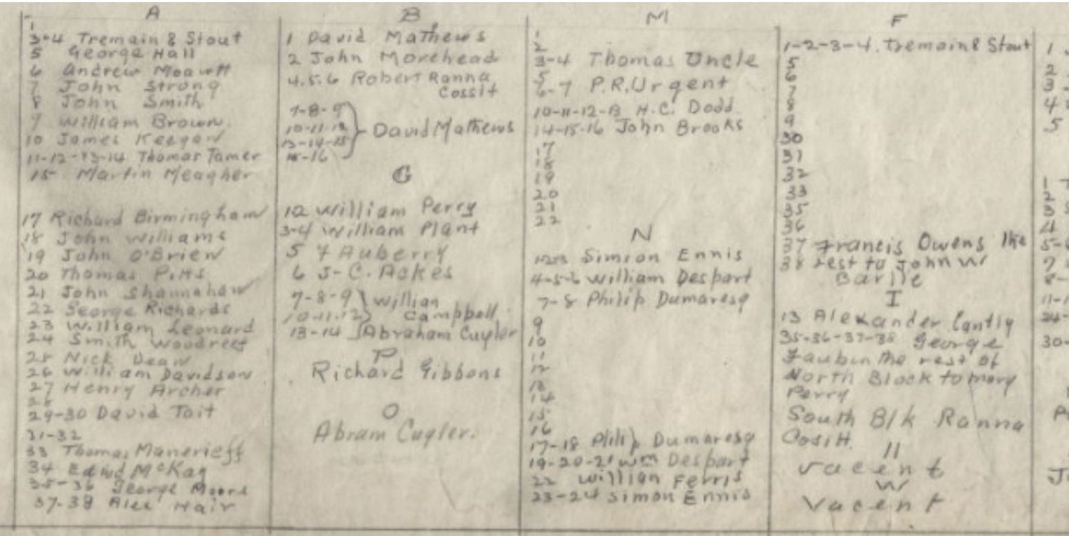
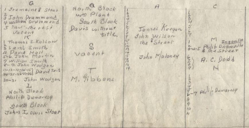
"NAMES OF GRANTEES" ...
------------------------------------------------------
NOTE
"27 Henry Archer"
# 27 is 54 Charlotte Street (Corner of Amelia Street and Charlotte Street) and exists in one of two Blocks named "A": The first "A" exists between DesBarres Street and Amelia Street, and the second "A" to the south of it , that includes #27, exists between Amelia Street and Yorke Street. The plan, though dated 1785, has additions showing it to be later, such as "old Government House and Gardens now Court House [built 1786] and Jail." This plan does not indicate buildings - rather it just puts names to lots.
[Source: PANS, V7, 1239-1785 Sydney]
NOT DATED
[c. 1838]
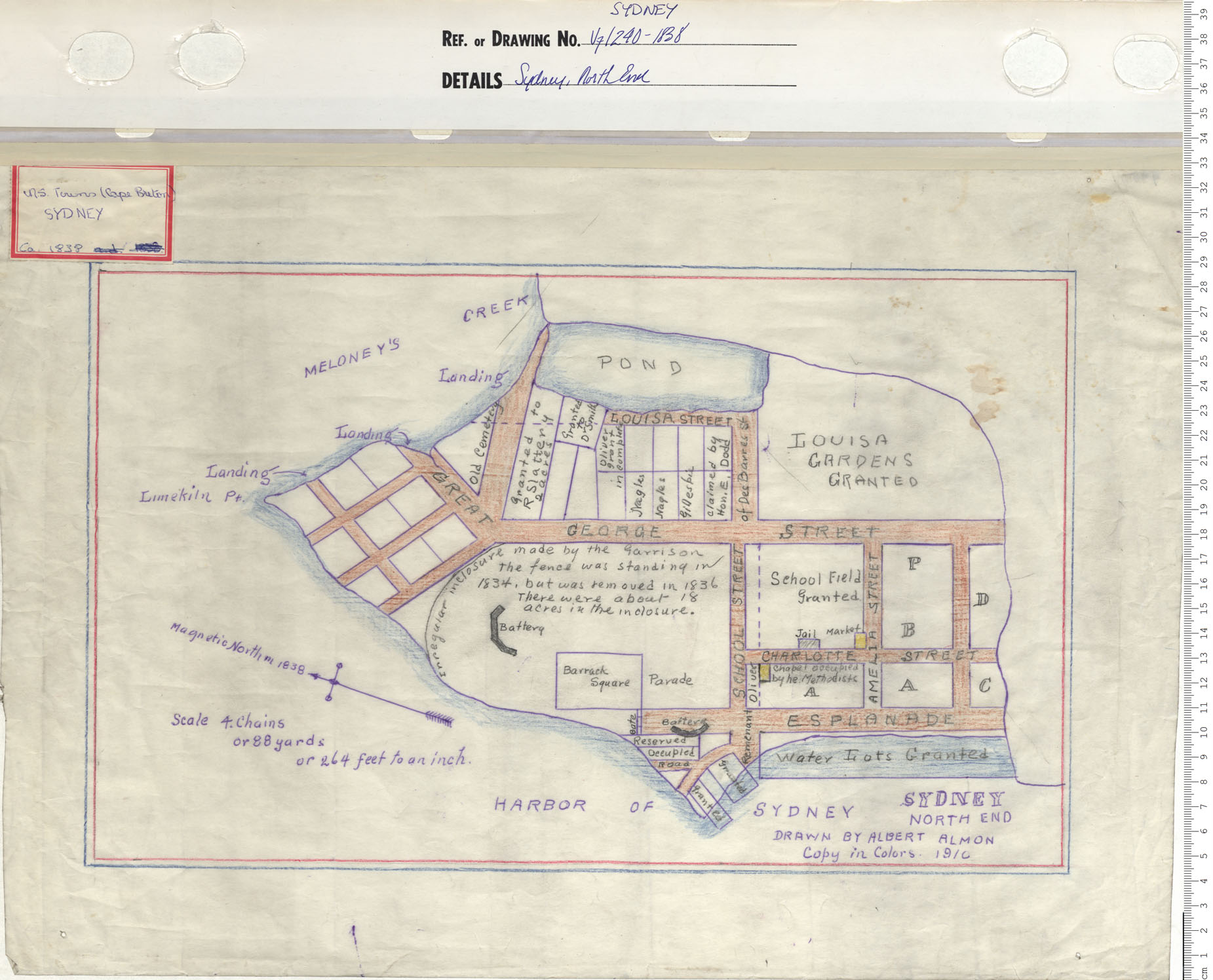
"SYDNEY NORTH END"
"DRAWN BY ALBERT ALMON
Copy in Colors 1910"
Date: 1838 Reference: Nova Scotia Archives Map Collection: V7 240 Sydney, Nova Scotia
https://archives.novascotia.ca/images/mapsV7/201402265.jpg
1843
OCTOBER 22
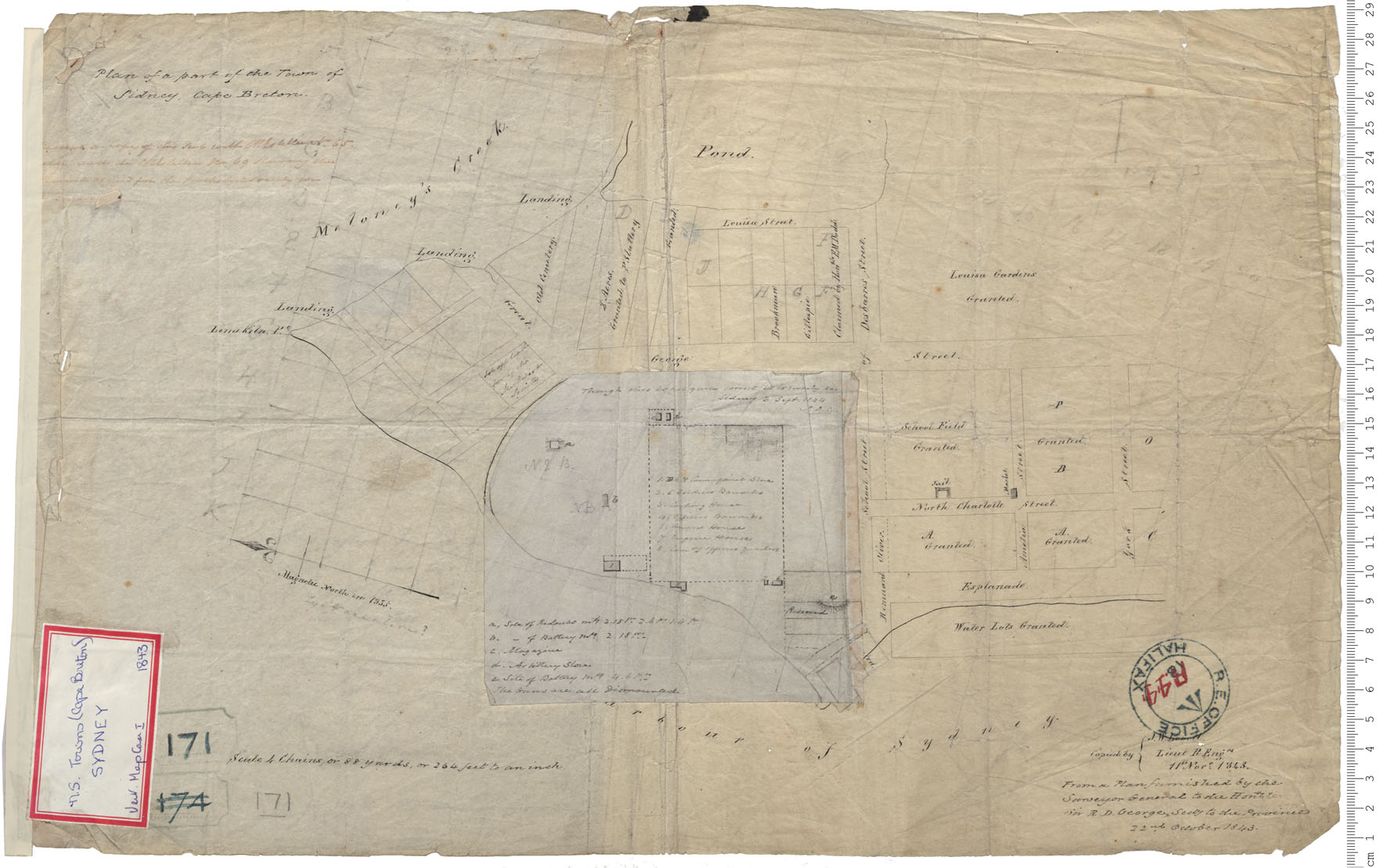
"Plan of a part of the Town of Sidney, Cape Breton"
"Copied by } [J. or T.] W. [?]
Lieut R. Engn
From a Plan furnished by the Surveyor General to the Honrble
Sir R. D. George, secty to the Province
22 nd. October 1843."
Date: 22 October 1843 Cartographer: H.W. Crawley, Surveyor General Reference: Nova Scotia Archives Royal Engineers Maps and Plans A.44
R. E. Office, Halifax R 44
https://archives.novascotia.ca/maps/archives/?ID=644
1848
NOVEMBER 30
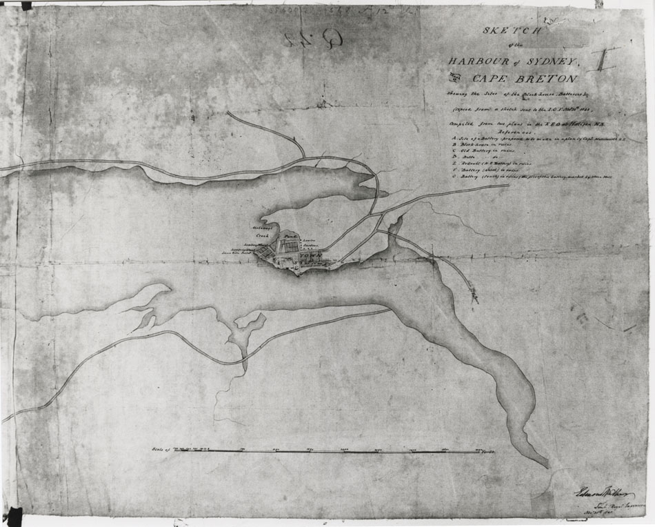
"SKETCH of the HARBOUR of SYDNEY, CAPE BRETON
shewing the Sites of the Block house, Batteries etc
copied from a sketch sent to the [I O Nov 30th 1833?]
compiled from 2 plans in the R E O at Halifax N.S."
[Signed] Edward " ? Lieut Royal Engineers ?
Sketch of the Harbour of Sydney, Island of Cape Breton Date: 1848 Reference: Nova Scotia Archives Map Collection: F/239 - 1848
Sketch of the Harbour of Sydney, Island of Cape Breton shewing the sites of the Blockhouse, Batteries, etc. [PANS F/239-1848]
1849
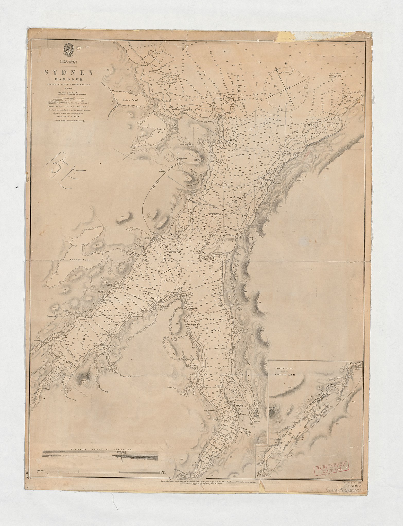
"NORTH AMERICA
BRETON ISLAND
---------------
SYDNEY
HARBOUR
"SURVEYED BY CAPT.N H. W. BAYFIELD R.N. F.A.S.
1849"
------------------------------------------------------
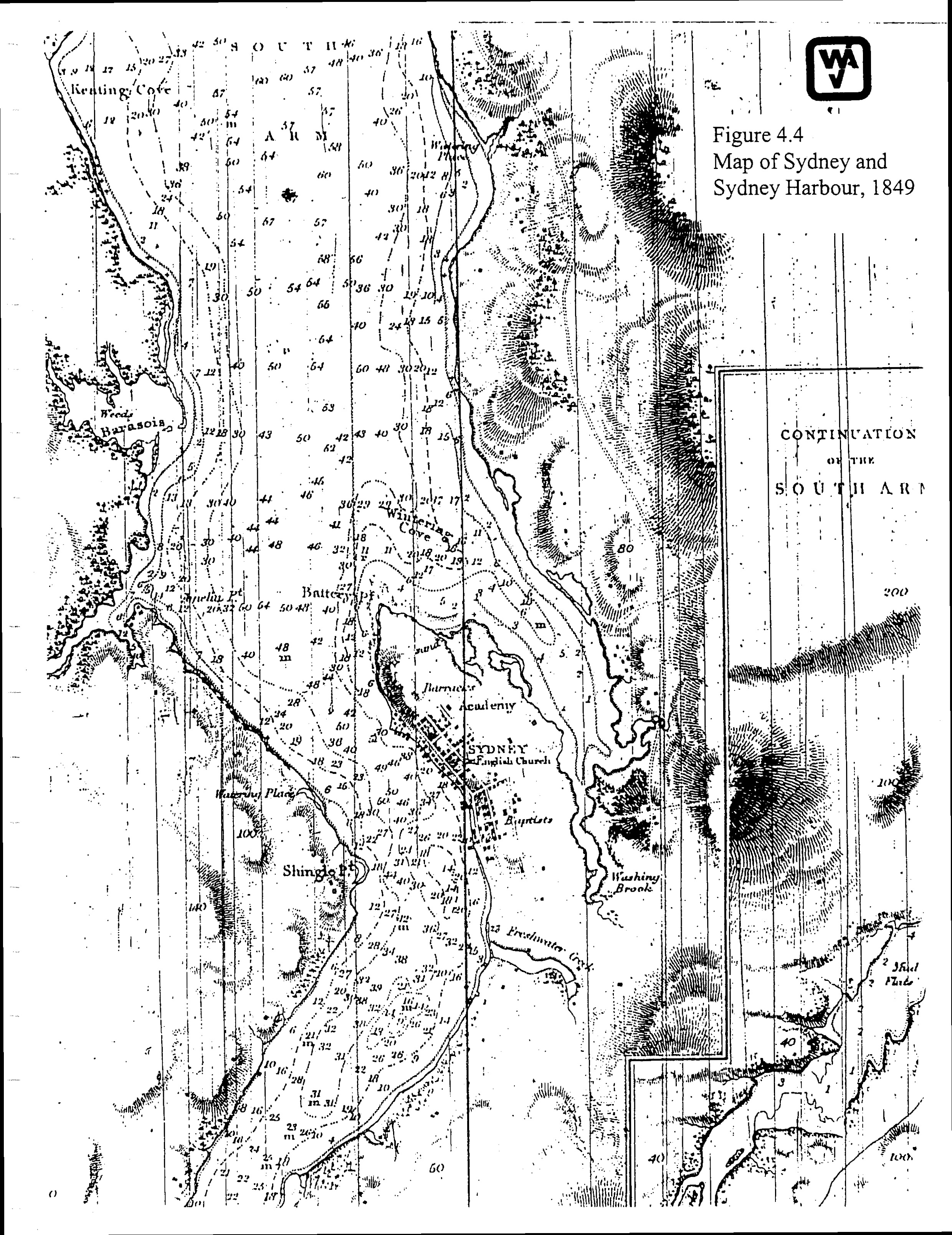
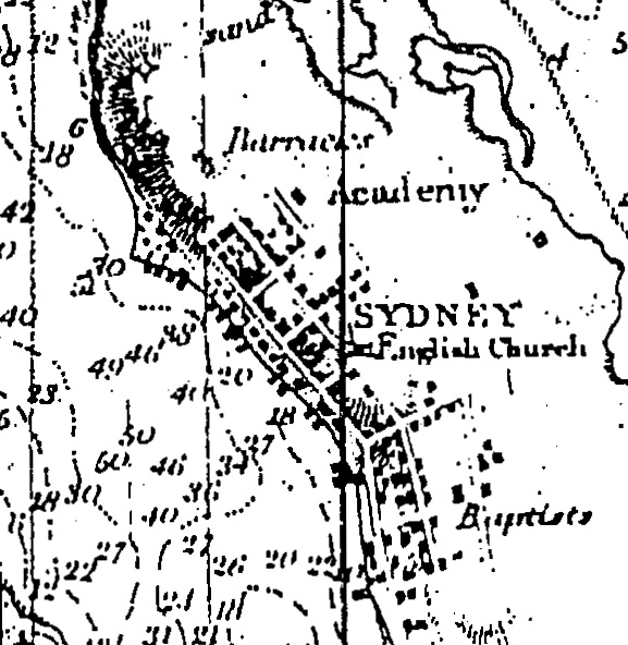
JPEGS
[1849 - Sydney Harbour - Surveyed by Captain H. W. Bayfield]
http://www.ceaa.gc.ca/050/documents_staticpost/cearref_8989/JWEL-12.pdf
http://www.ceaa.gc.ca/050/documents_staticpost/cearref_8989/JWEL-17.pdf
1850
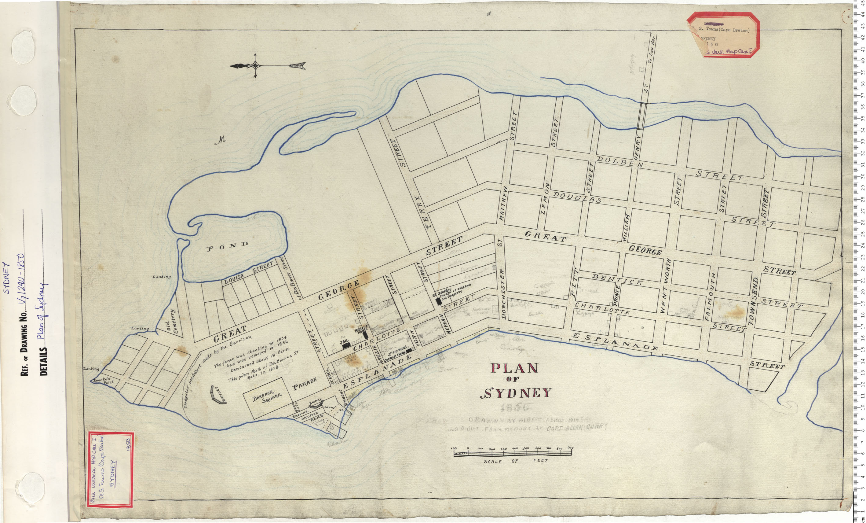
"PLAN OF SYDNEY"
[ADDED IN PENCIL]:
"1850
DRAWN BY ALBERT ALMON [1918919]
LAID OUT, FROM MEMORY BY CAPT ALLAN CURRY"
"JOST" building facing Amelia Street [Added in Pencil]
Plan of Sydney Date: 1850 Reference: Nova Scotia Archives Map Collection: V7 240 Sydney, Nova Scotia
https://archives.novascotia.ca/maps/archives/?ID=689
NOT DATED
[AFTER 1864]
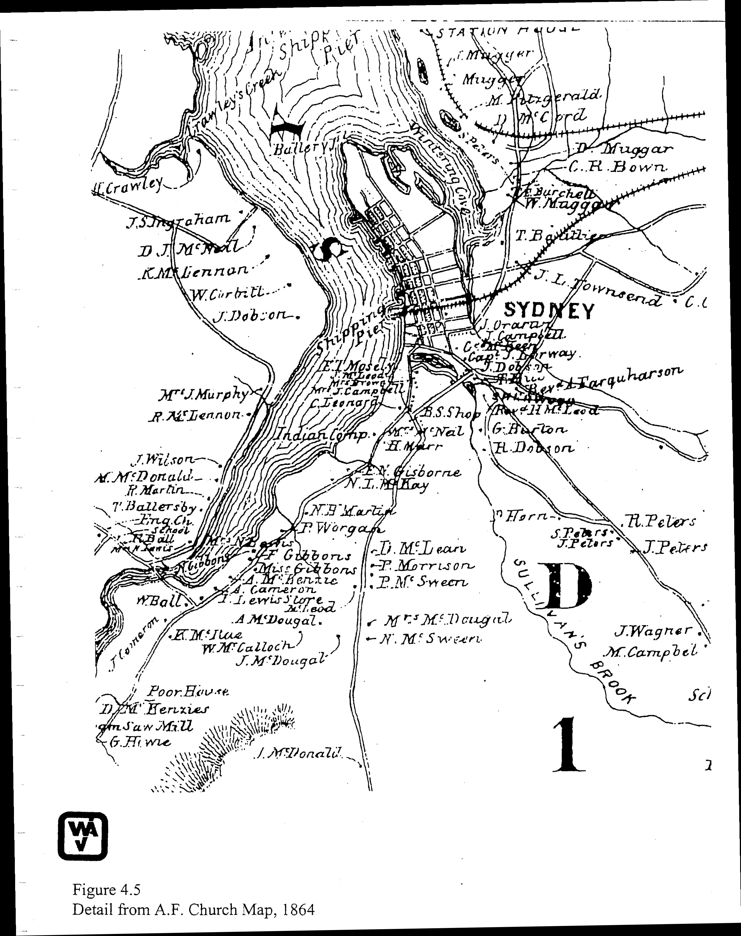
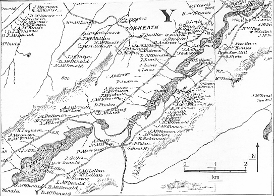
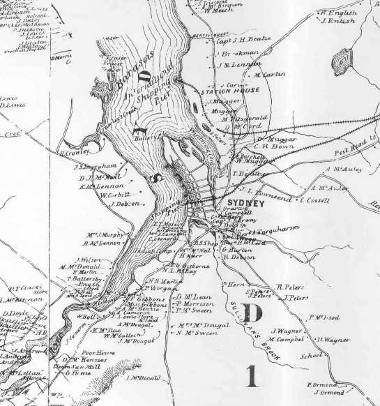
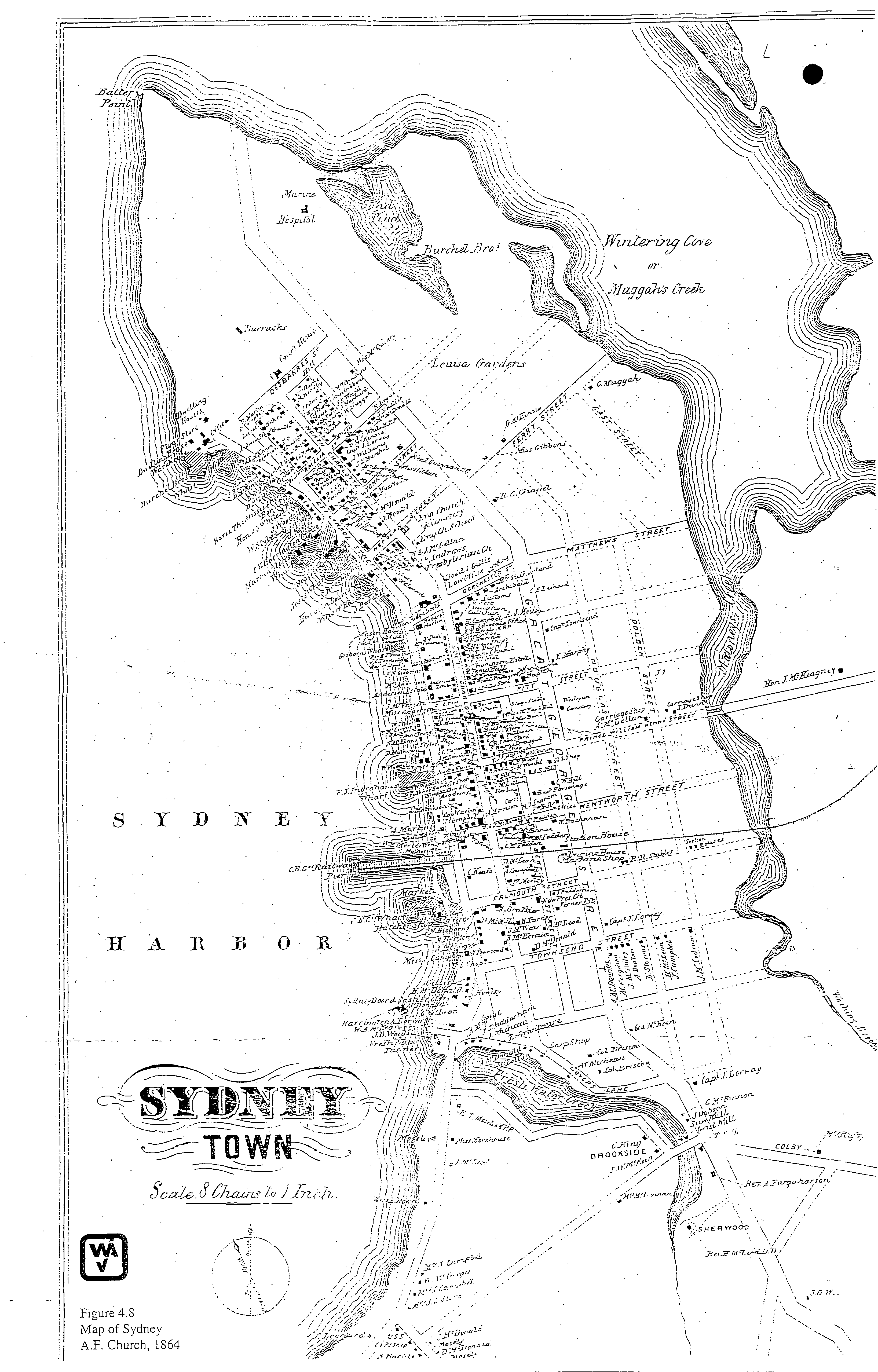
JPEGS
[NO TITLE]
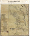
Public Archives of Nova Scotia, A. F. Church, A Topographical Map of the County of Cape Breton, Nova Scotia, and Sydney Town [Insert], 1864 [Published 1877] - [PANS V7/239 Sydney 1877] [ Minister of Natural Resources]
[Church, Ambrose F. "Topographical Township Map of Cape Breton County," Nova Scotia, 1864, pub. 1877.]
http://www.ceaa.gc.ca/050/documents_staticpost/cearref_8989/JWEL-12.pdf
------------------------------------------------------
Public Archives of Nova Scotia, A. F. Church, A Topographical Map of the County of Cape Breton, Nova Scotia, and Sydney Town [Insert], 1864 [Published 1877] - [PANS V7/239 Sydney 1877]
[Church, Ambrose F. "Topographical Township Map of Cape Breton County," Nova Scotia, 1864, pub. 1877.]
ftp://142.176.49.195/EIS/VOL1-09-AppendixG-N.pdf
"A.F. Church Maps - In 1864, Ambrose F. Church was commissioned by the Nova Scotia legislature to create a series of maps, one for each of Nova Scotia's 18 counties. Each shows the locations of towns and villages, basic topographic features and the names of residents. In many cases, the occupation of prominent townsfolk (clergy, blacksmith, merchant) was also included. Mr. Church completed the series in 1888 " - http://www.rootsweb.ancestry.com/~canns/nat_res.html
NOT DATED
[BEFORE 1877]
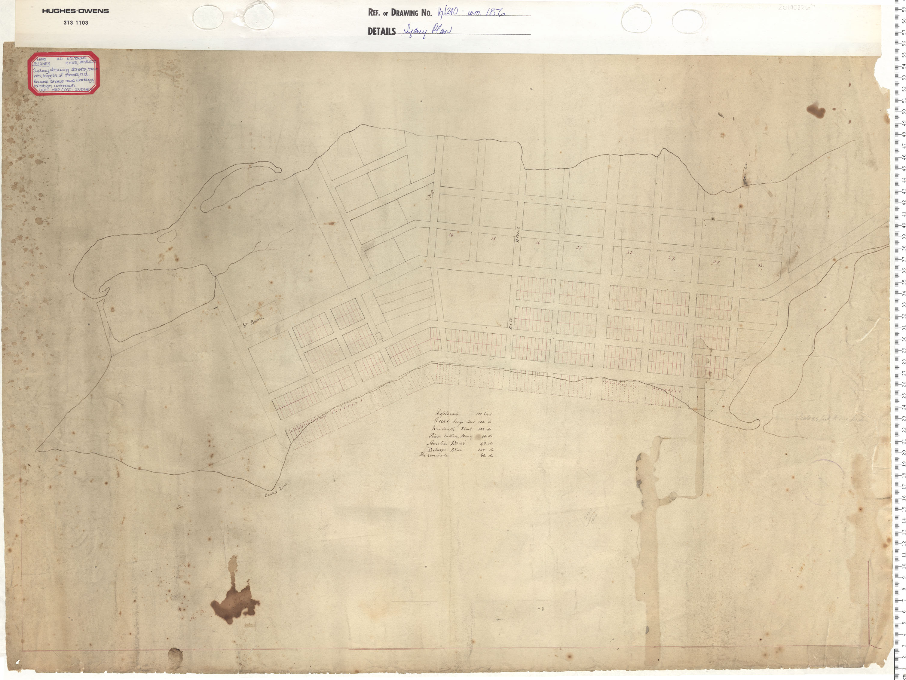
[NO TITLE]
"Esplanade 100
feet
Great George Street 100. do.
Wentworth Street 100.
do.
Prince William Henry 40. do
Amelia Street 40.
do
Debares 100.
do
The remainder 60. do"
Sydney Plan Date: 1856 Reference: Nova Scotia Archives Map Collection: V7 240 Sydney, Nova Scotia
M/22A
https://archives.novascotia.ca/maps/archives/?ID=738
NOT DATED
[BEFORE 1877]
![]()
![]()
"Plan of Sydney
Names of Streets Width
of
Streets
Feet
Esplanade
100
Great George
100
Des Barres
100
Wentworth 100
Amelia
40
Prince William Henry 40
[Lessor ?] 40
The Others
60
Building Lots 40
by
100
Scale 4 Chains to an Inch "
Plan of Sydney/A C Thompson Property Sydney, N.S. Reference: Nova Scotia Archives Map Collection: F/240
[M/22A]
https://archives.novascotia.ca/maps/archives/?ID=1214
NOT DATED
[BEFORE 1877]
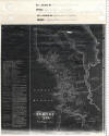
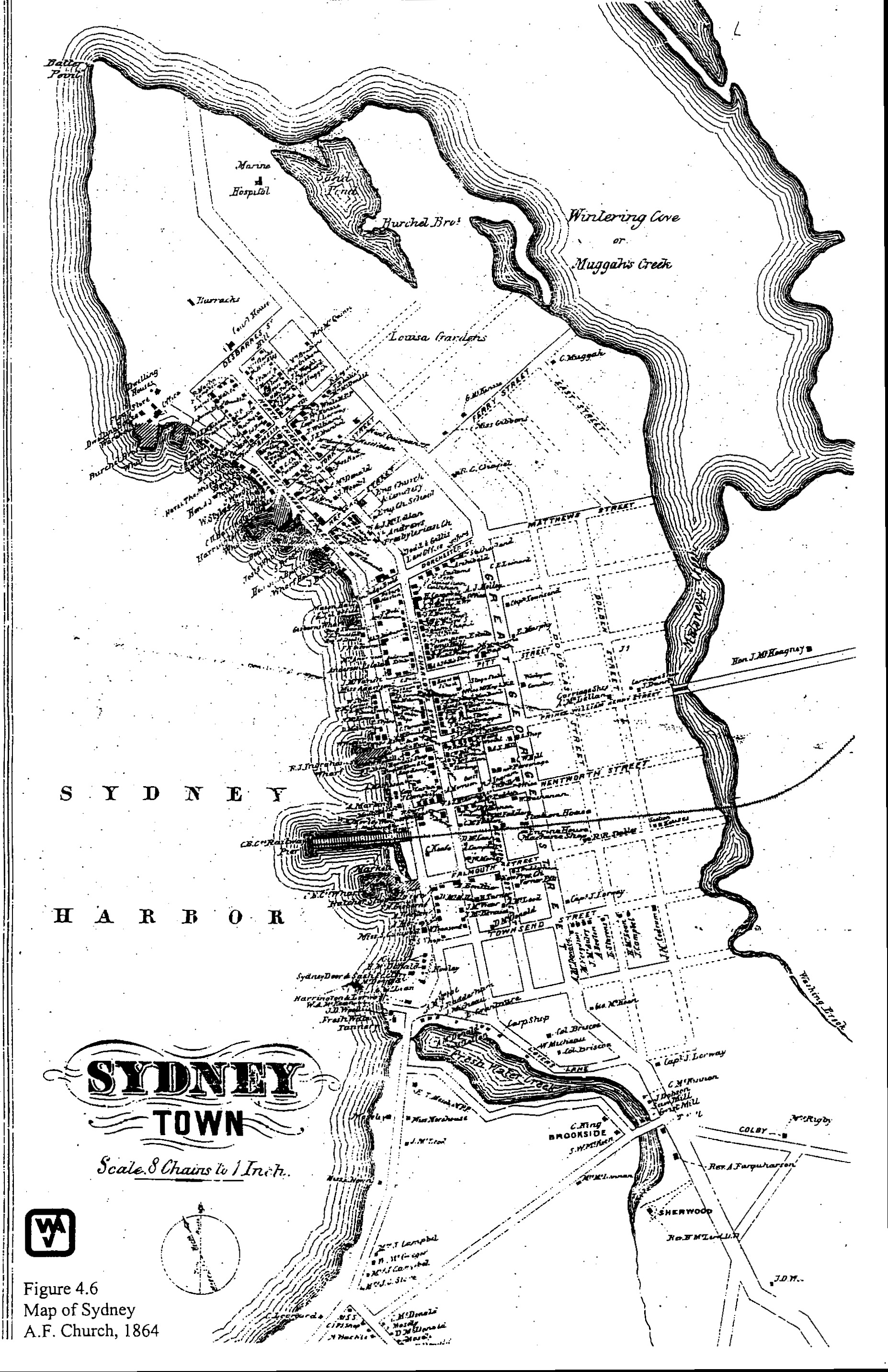
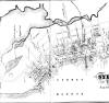
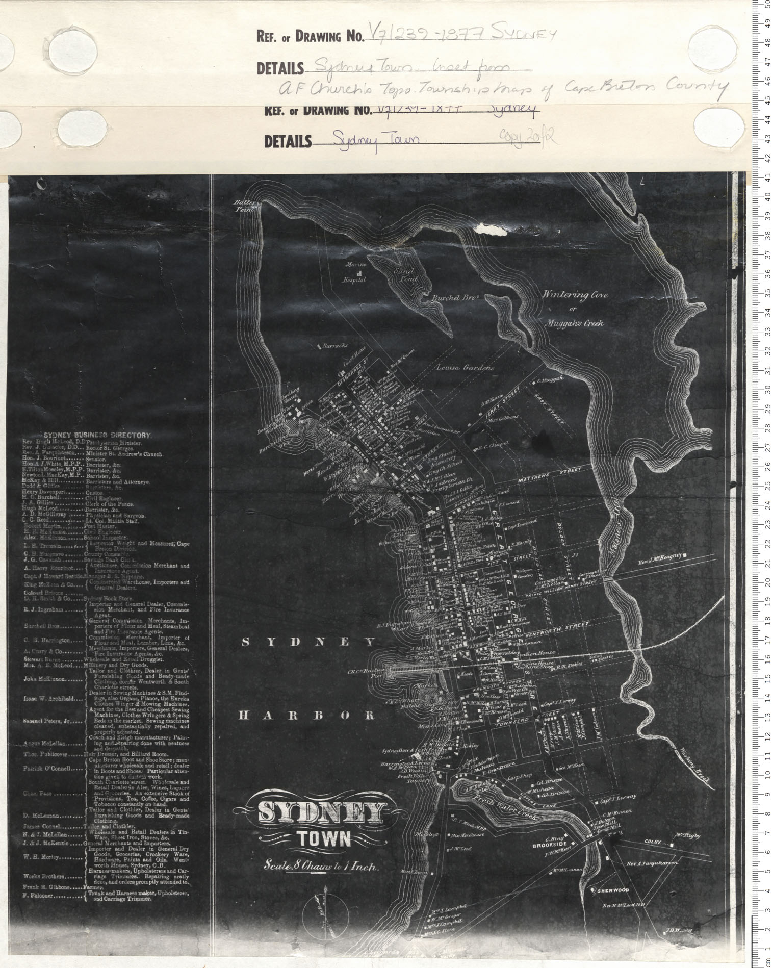
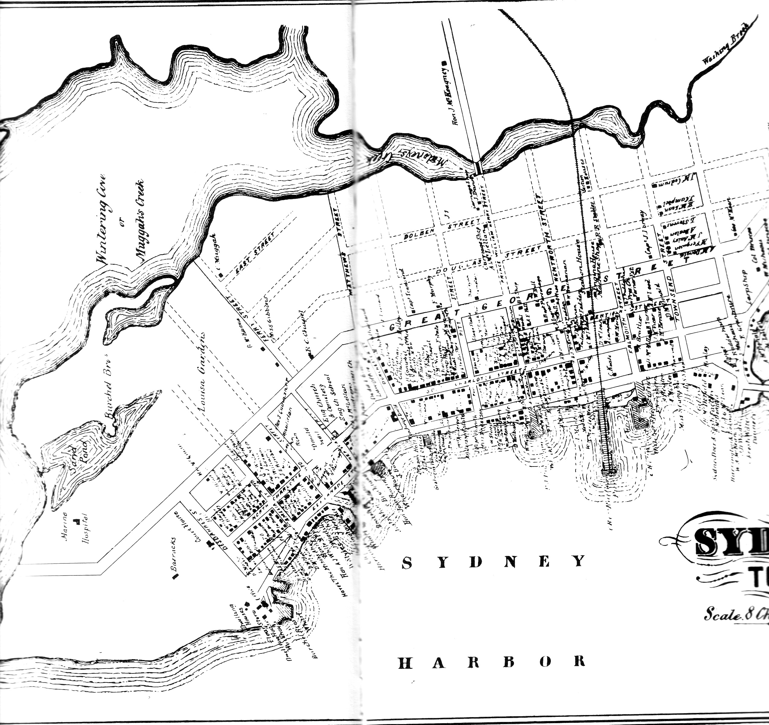
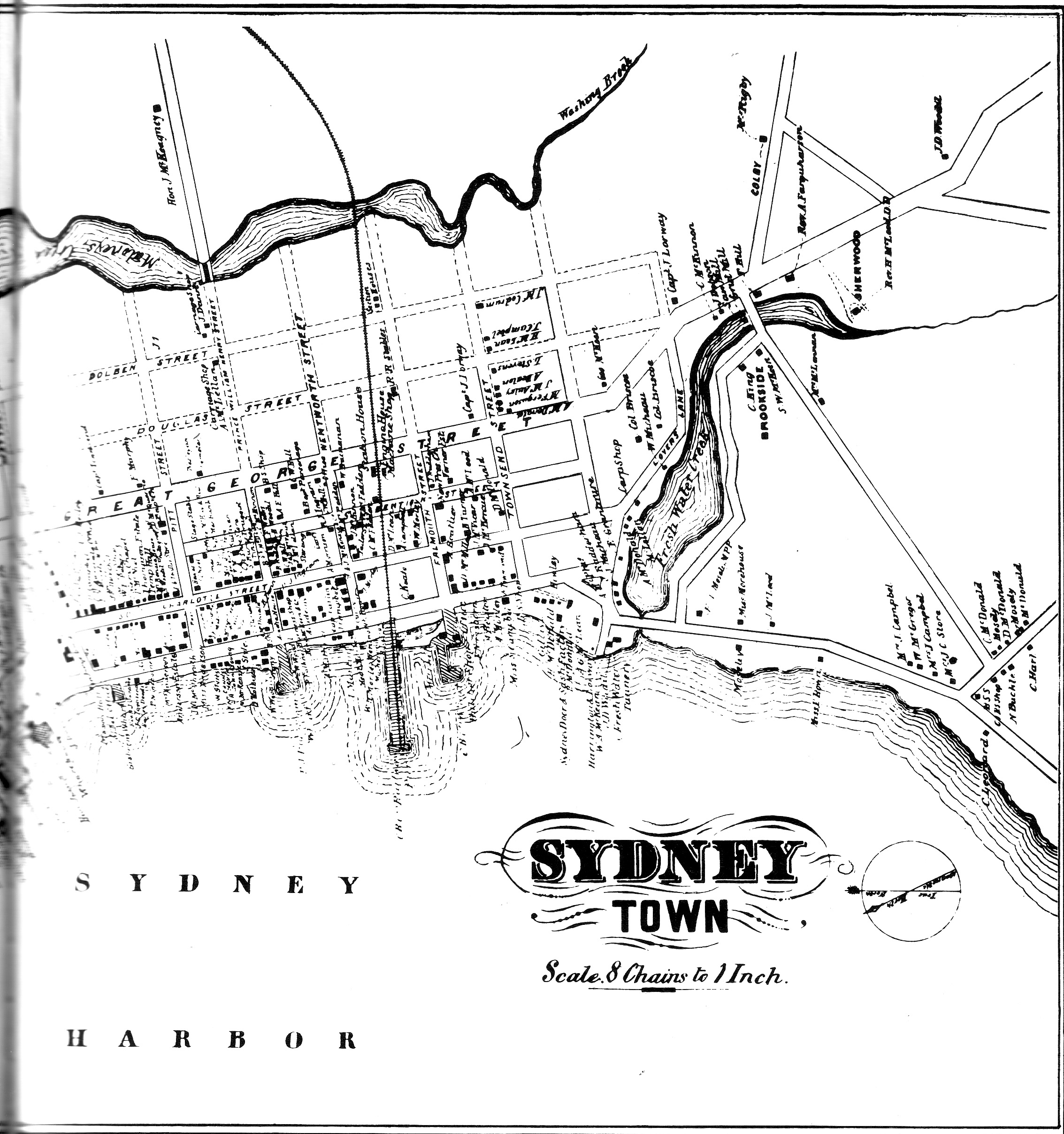
"SYDNEY TOWN"
"Scale. 8 Chains to 1 Inch."
"SYDNEY BUSINESS DIRECTORY"
Sydney Township Inset from A.F. Church's Township Maps of Cape Breton County Date: 1877 Reference: Nova Scotia Archives Map Collection: V7 239 Sydney, Nova Scotia
[Church, Ambrose F. "Topographical Township Map of Cape Breton County," Nova Scotia, 1864, pub. 1877.]
https://archives.novascotia.ca/maps/archives/?ID=958
------------------------------------------------------
"SYDNEY TOWN"
"Scale. 8 Chains to 1 Inch."
"SYDNEY BUSINESS DIRECTORY"
Sydney Township Inset from A.F. Church's Township Maps of Cape Breton County Date: 1877 Reference: Nova Scotia Archives Map Collection: V7 239 Sydney, Nova Scotia
[Church, Ambrose F. "Topographical Township Map of Cape Breton County," Nova Scotia, 1864, pub. 1877.]
https://archives.novascotia.ca/maps/archives/?ID=958&Page=201402271
------------------------------------------------------
------------------------------------------------------

JPEG
[NO DATE]
"SYDNEY TOWN"
"Scale 8 Chains to 1 Inch."
Public Archives of Nova Scotia, A. F. Church, A Topographical Map of the County of Cape Breton, Nova Scotia, and Sydney Town [Insert], 1864 [Published 1877] - [PANS V7/239 Sydney 1877] [ Minister of Natural Resources]
[Church, Ambrose F. "Topographical Township Map of Cape Breton County," Nova Scotia, 1864, pub. 1877.]
http://www.ceaa.gc.ca/050/documents_staticpost/cearref_8989/JWEL-17.pdf
------------------------------------------------------
Reproduced in Debra McNabb, Old Sydney Town, Historic Buildings of the North End (Sydney: Old Sydney Society, 1986), p. 54
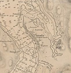
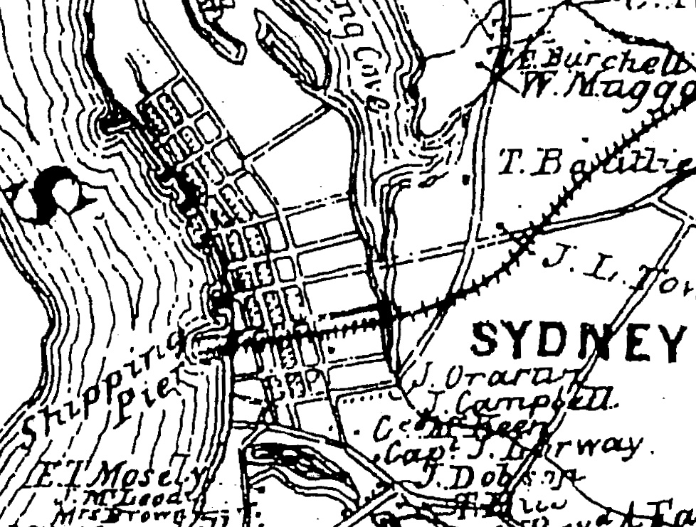
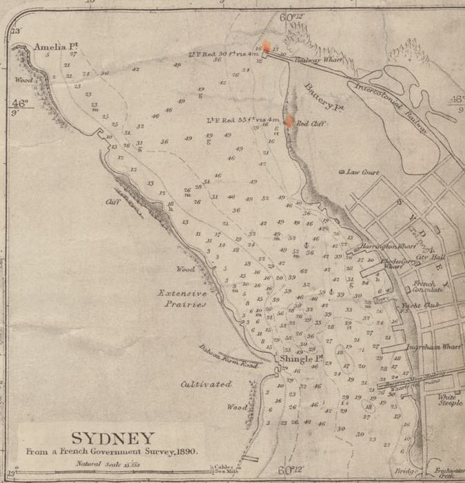
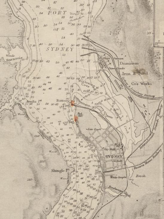
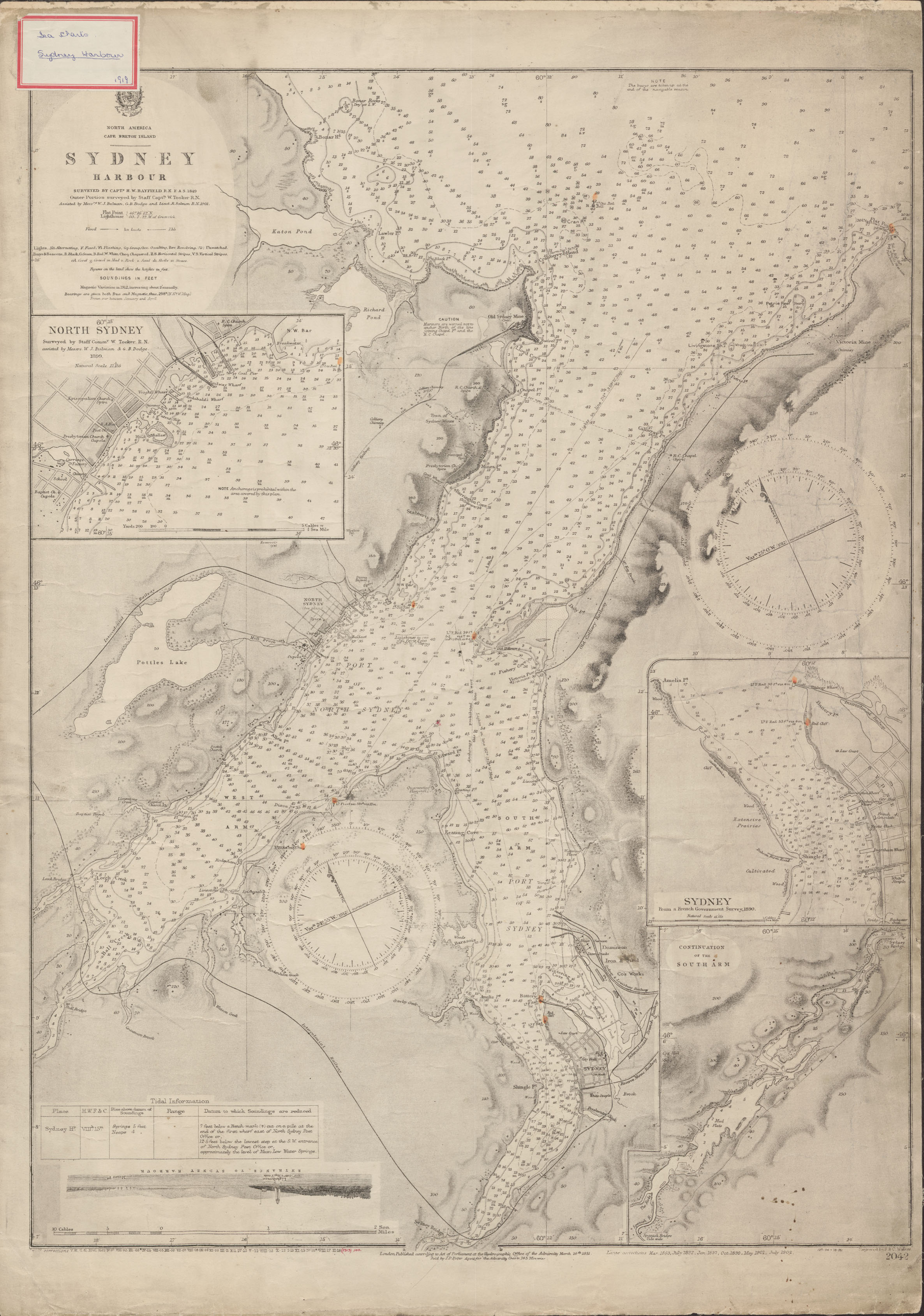
1890
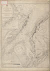
"SYDNEY
From a French Government Survey, 1890"
"North America Cape Breton Island Sydney Harbour", surveyed by Captain H.W. Bayfield Date: 1849, with corrections to 1902 Reference: Nova Scotia Archives Map Collection: Great Britain Hydrographic Office, Chart No. 2042
https://archives.novascotia.ca/images/builtheritage/200804572.jpg
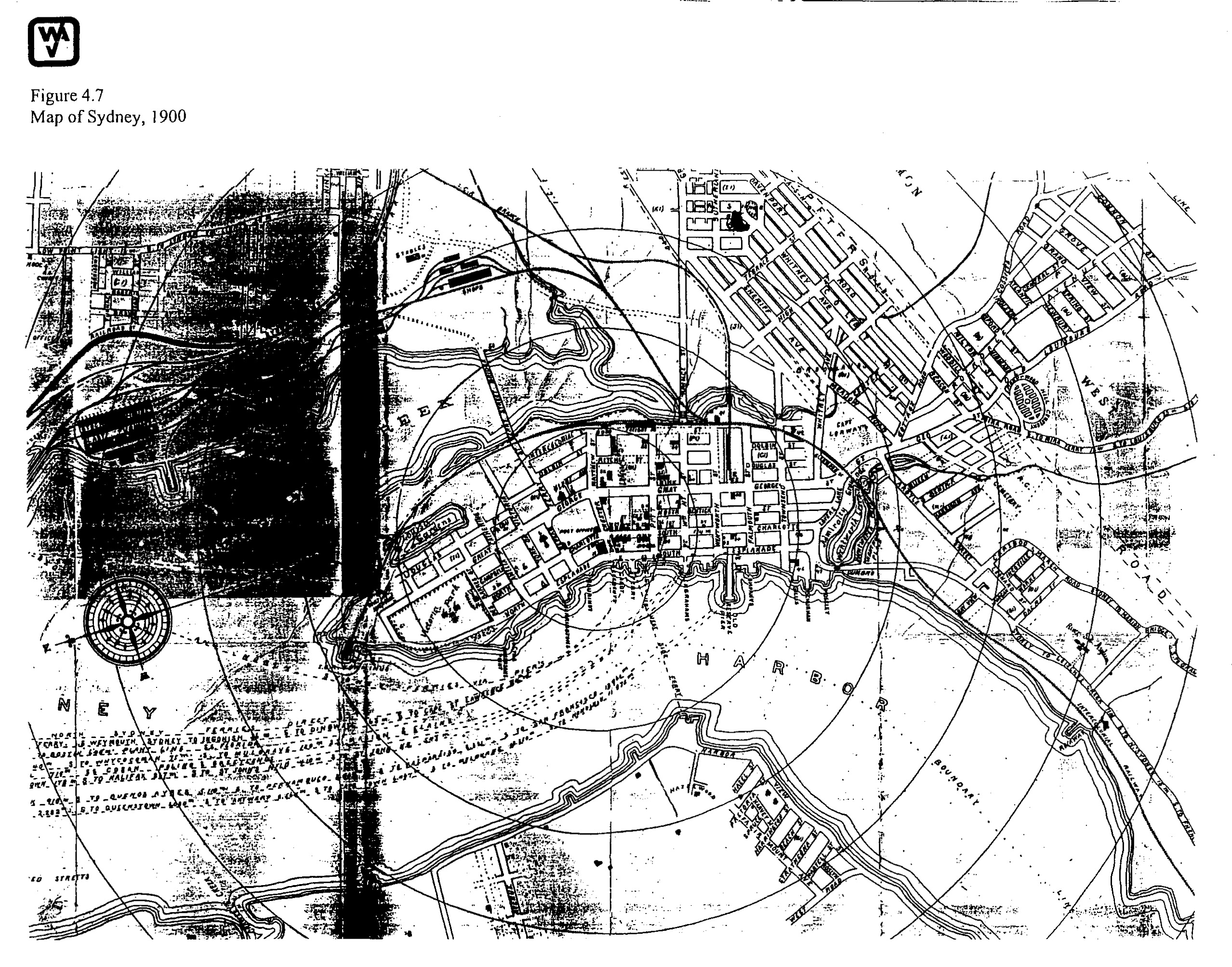
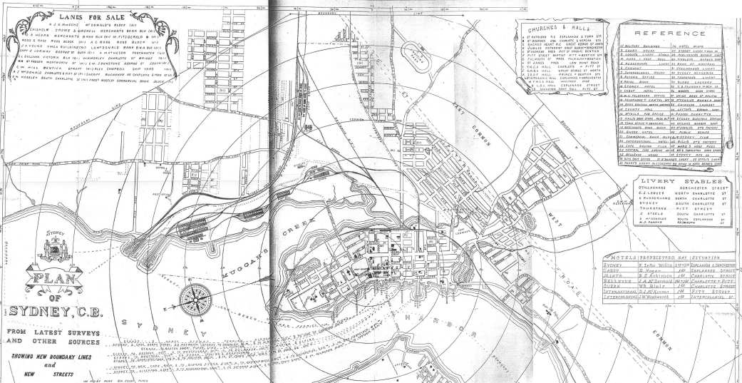
1900
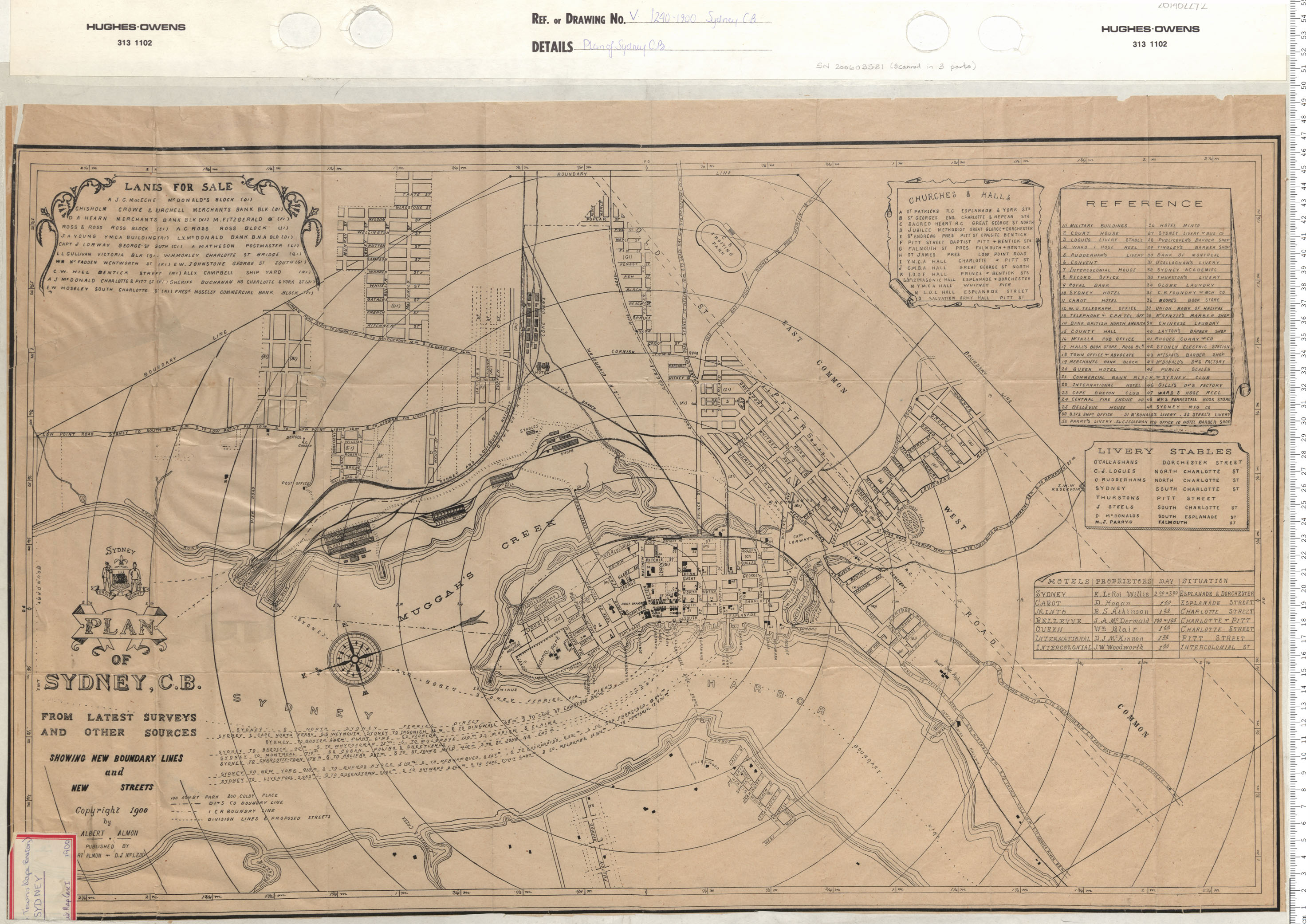
"PLAN OF SYDNEY, C.B.
FROM LATEST SURVEYS AND OTHER SOURCES
SHOWING NEW BOUNDARY LINES and NEW STREETS
Copyright 1900 by ALBERT ALMON
PUBLISHED BY ALBERT ALMON ... D J MCLEOD
LANDS FOR SALE
CHURCHES & HALLS
REFERENCE
LIVERY STABLES
HOTELS | PROPRIETORS | DAY | SITUATION"
Plan of Sydney, Cape Breton Date: 1900 Reference: Nova Scotia Archives Map Collection: V7 240 Sydney, Nova Scotia
"Plan of Sydney, C. B. From Latest Surveys and Other Sources, showing new boundary lines and new streets. .... Albert Almon. "
https://archives.novascotia.ca/maps/archives/?ID=1265
------------------------------------------------------
------------------------------------------------------
JPEG
1900 Plan of Sydney, C. B. From Latest Surveys and Other Sources, showing new boundary lines and new streets. Albert Almon. [PANS V7/240-1900] - (pcx)
http://www.ceaa.gc.ca/050/documents_staticpost/cearref_8989/JWEL-12.pdf
http://www.ceaa.gc.ca/050/documents_staticpost/cearref_8989/JWEL-17.pdf
------------------------------------------------------
GIF
1900 Plan of Sydney, C. B. From Latest Surveys and Other Sources, showing new boundary lines and new streets. Albert Almon. [PANS V7/240-1900]
ftp://142.176.49.195/EIS/VOL1-09-AppendixG-N.pdf
1900
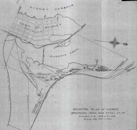
JPEG
General Plan of Works, Dominion Iron and Steel Co. Ltd. Sydney, C. B. April 7, 1900. [Beaton Institute Plan # 115]
ftp://142.176.49.195/EIS/VOL1-09-AppendixG-N.pdf
1901
"NORTH AMERICA
CAPE BRETON ISLAND
---------------
SYDNEY
HARBOUR
SURVEYED BY CAPT.N H. W. BAYFIELD R.N. F.A.S. 1849
Outer Portion surveyed by Staff Capt.n W. Tooker R.N.
Assisted by Mess.rs W.J. Bulman, G.B. Dodge and Lieut R. Salman R.N. 1901."----------------
"North America Cape Breton Island Sydney Harbour", surveyed by Captain H.W. Bayfield Date: 1849, with corrections to 1902 Reference: Nova Scotia Archives Map Collection: Great Britain Hydrographic Office, Chart No. 2042
https://archives.novascotia.ca/images/builtheritage/200804572.jpg
NOT DATED
[POST 1901]
[NO TITLE]
"Cape Breton Electric Co's Track" highlighted in red
Sydney Date: Reference: Nova Scotia Archives Map Collection: V7 239 Sydney, Nova Scotia
https://archives.novascotia.ca/maps/archives/?ID=1618
1902

JPG IMAGE
https://www.bac-lac.gc.ca/eng/collectionsearch/Pages/collectionsearch.aspx
------------------------------------------------------
------------------------------------------------------
------------------------------------------------------
MACDONALD, W.A., McAlpine Publishing Company Limited, Plan of the Town of Sydney published by McAlpine Publishing Co. Limited, Halifax, N.S. Compiled by W.A. MacDonald, Town Engineer. Date: 1892[1902], Microfiche Number: 18563, Ecopy Number(s): n0018563, Call Number: H2/240/Sydney/1892[1902] Record No.: 813
[NOTE: The Beaton Institute (CBU) has many early street directories and phone directories for Cape Breton Island. For example: 1902, 1903-1904, 1905, 1907-1908, 1914, 1918-1919, 1923, 1928, 1935, 1938, 1947, 1948, 1950, 1972, 1974, 1976, 1978, 1982]
1907
Goad’s Fire Insurance Plan. Town of Sydney. Sheet 27. [Beaton Institute]
1908

JPG IMAGE
H2/240/Sydney/1908
Source:
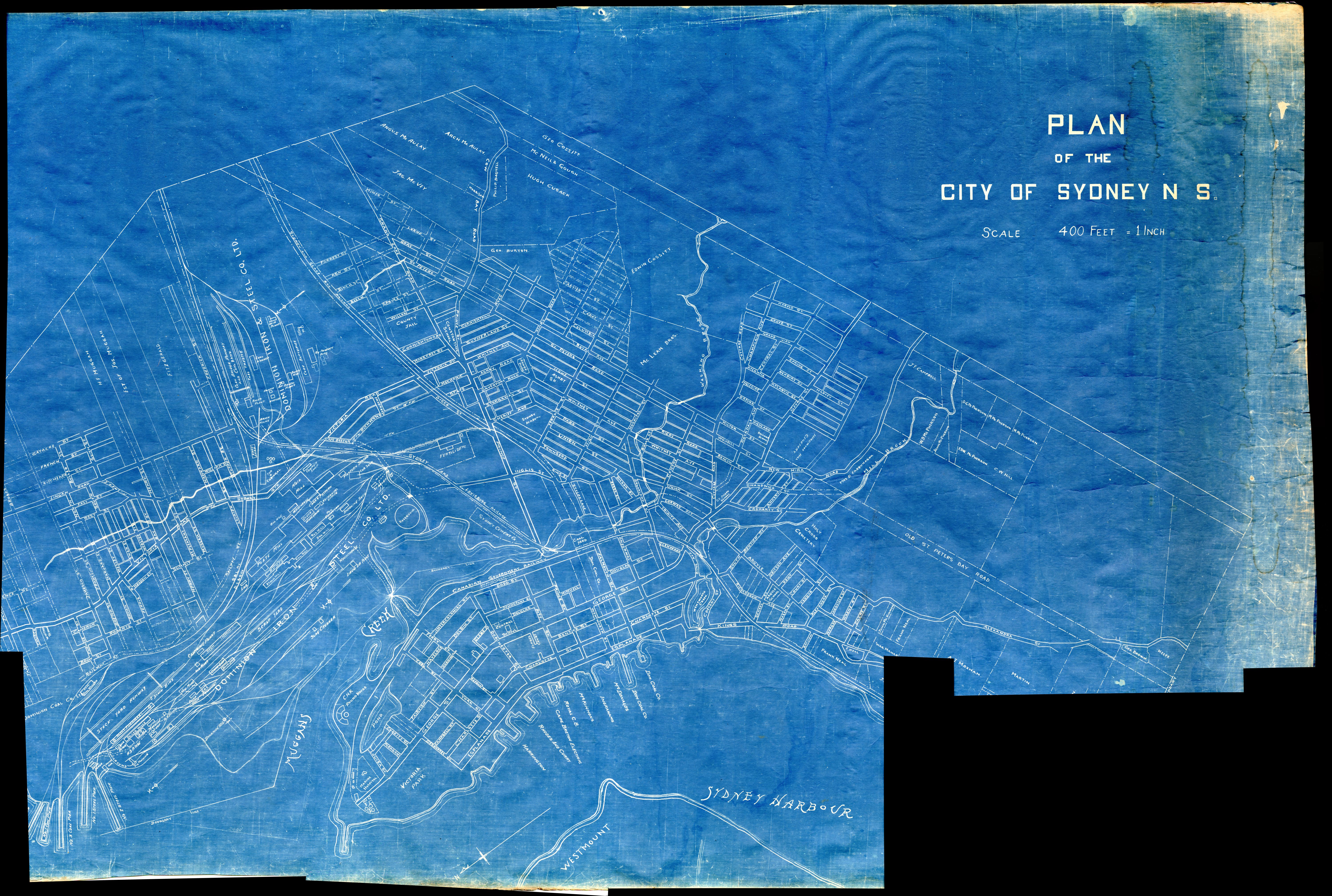
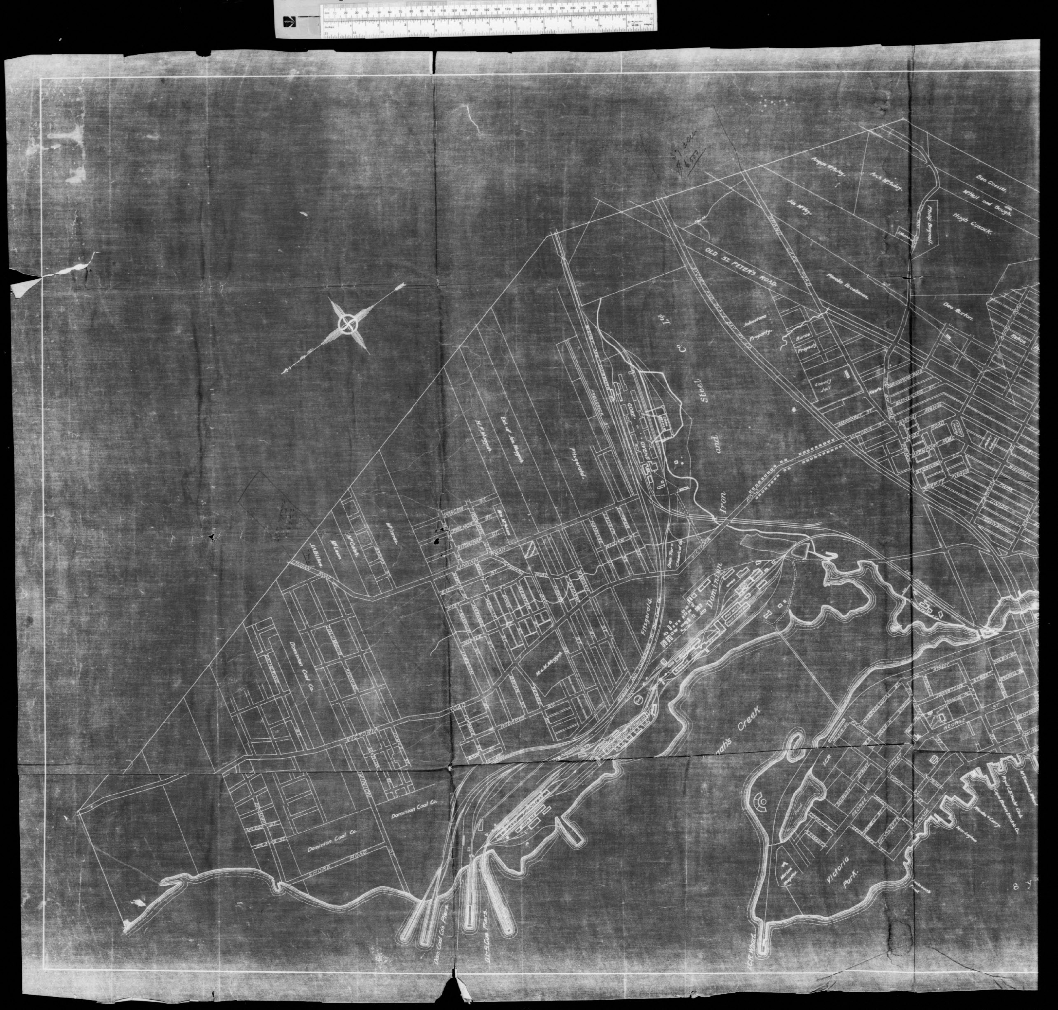
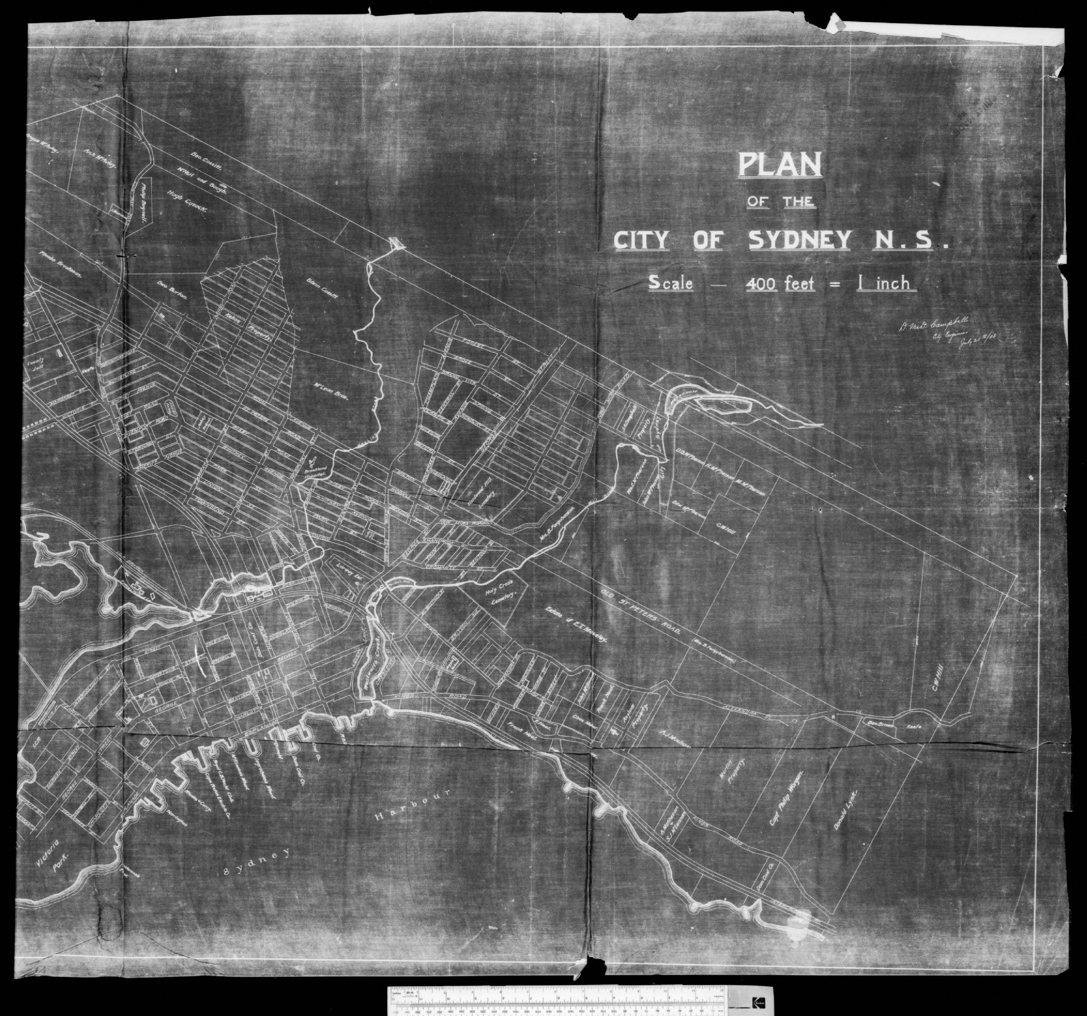
CAMPBELL, D. Mc D. Plan of the City of Sydney, N.S. D. Mc D. Campbell, City Engineer. July 25th/08. Date: 1908
Plan of the City of Sydney, N.S. D. Mc D. Campbell, City Engineer. July 25th/08. [cartographic material]
Maps & cartographic material. [Conditions of access Open]. Private. Item.
Plan of the City of Sydney, NSD Mc D. Campbell, City Engineer. July 25th/08. [ cartographic material]. Shows Dom. Iron & Steel Co. works. The microfiche versionFound in: Library and Archives Canada (LAC)
Archives / Collections and Fonds
Local class no.: H2/240/Sydney/1908Box number: 20002084621908 - Library and Archives of Canada: CAMPBELL, D. Mc D.. Plan of the City of Sydney, N.S. D. Mc D. Campbell, City Engineer. July 25th/08, 1908, Microfiche Number: 98659, Ecopy Number(s): n0098659_a1 n0098659_a2 Call Number: H2/240/Sydney/1908 Record No.: 814
https://www.bac-lac.gc.ca/eng/collectionsearch/Pages/collectionsearch.aspx
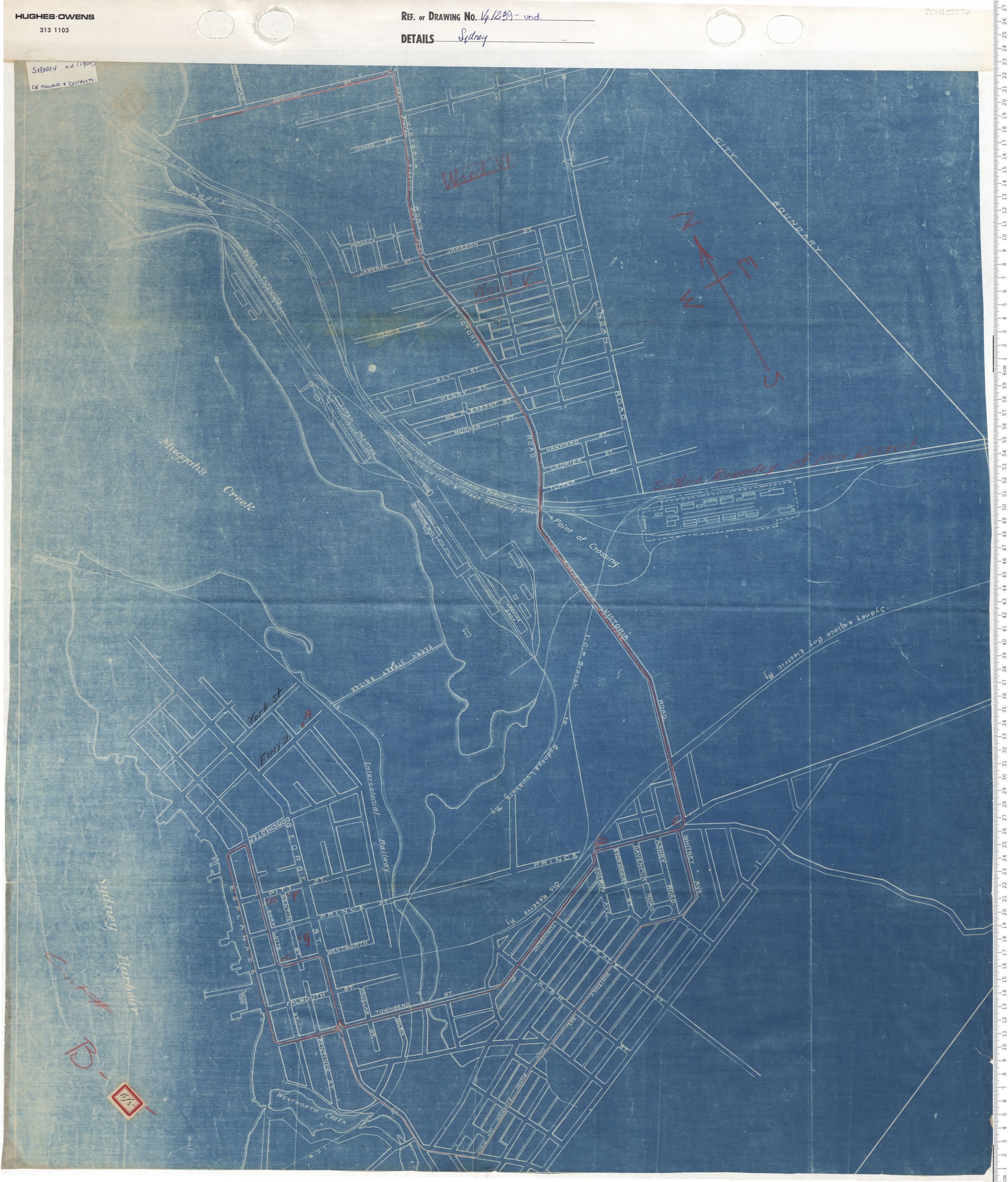
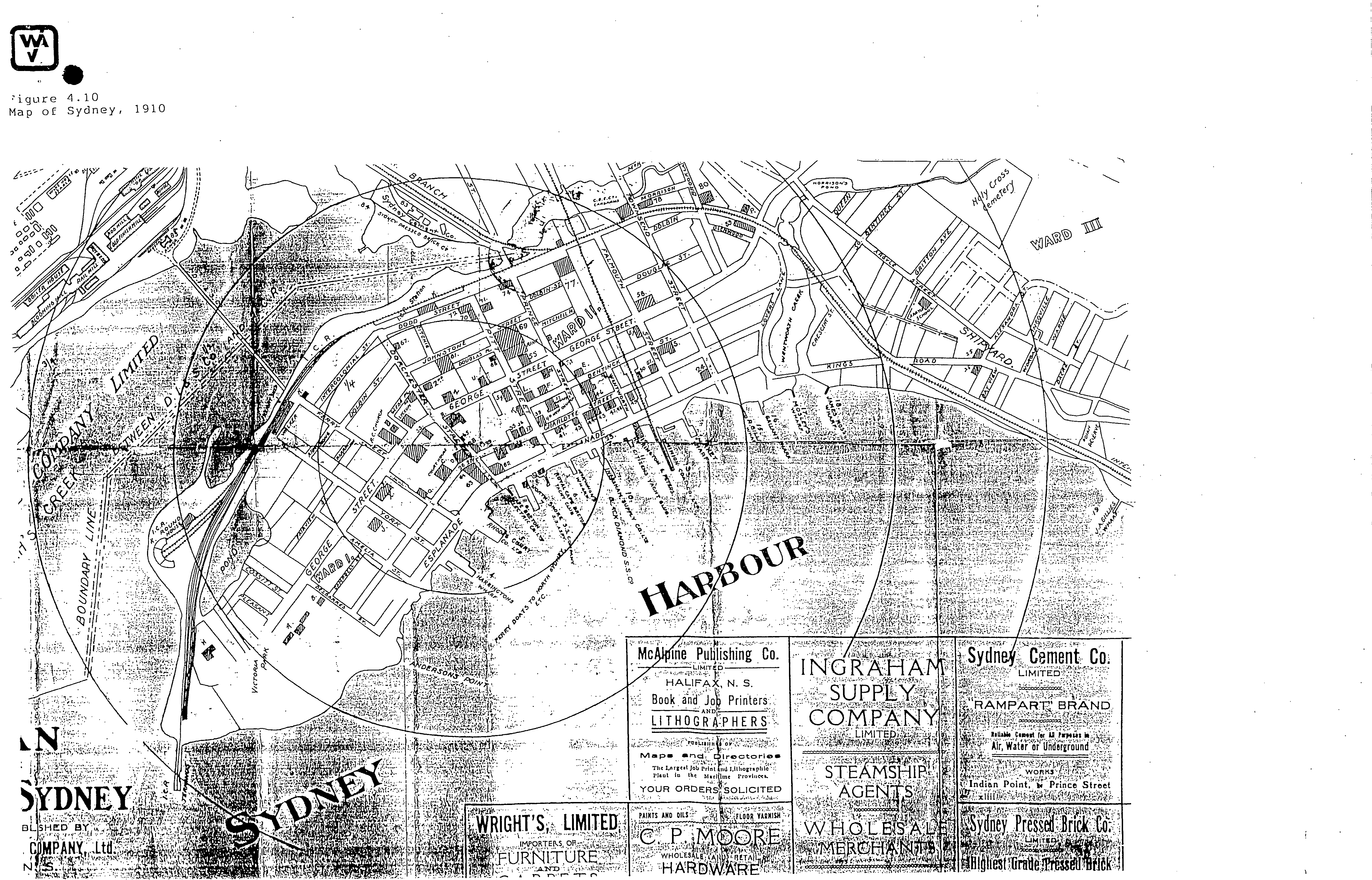
1910
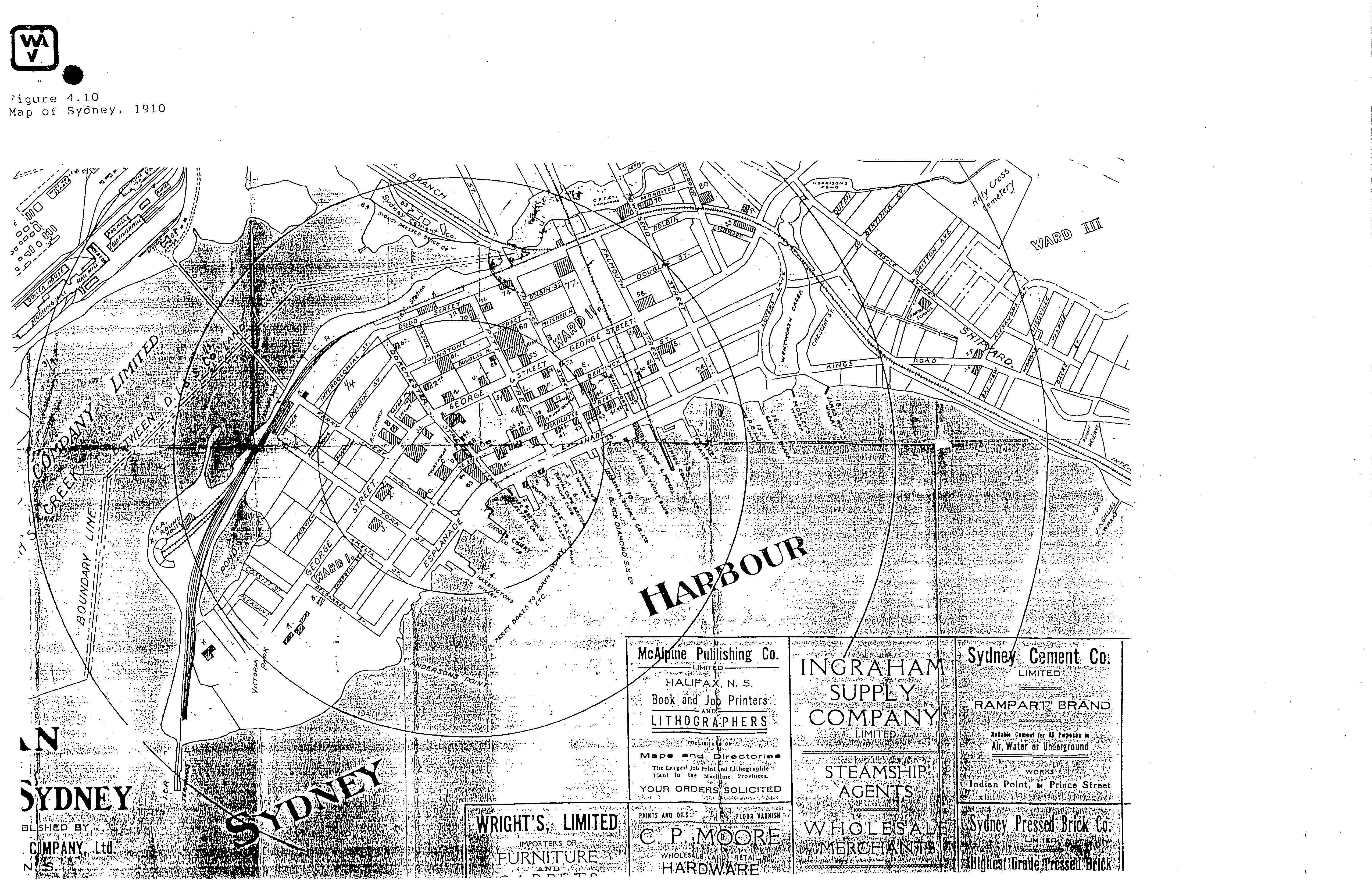
JPG IMAGE
"SYDNEY" .... " PUBLISHED BY"... "COMPANY, LTD" ... "N.S." ...
[Presently incomplete - future plans for a complete copy]
[McALPINE, Pub. Co. Ltd. Dominion Iron & Steel Co., Plan of the City of Sydney compiled and published by McAlpine Publishing Company, Ltd., Halifax, N.S., from latest surveys by City of Sydney, N.S., and Dominion Iron & Steel Co. , Ltd., 1910, Library and Archives of Canada, H1/240/Sydney/1910]
http://www.ceaa.gc.ca/050/documents_staticpost/cearref_8989/JWEL-12.pdf
http://www.ceaa.gc.ca/050/documents_staticpost/cearref_8989/JWEL-17.pdf
NOT DATED
[c. 1910]
JPG IMAGE
1910 (circa) - Plan of the City of Sydney, N S.. Provided by the Beaton Institute and Forwarded to Me by PC Dawson, December 29, 2020.
NOT DATED
[c. 1915]
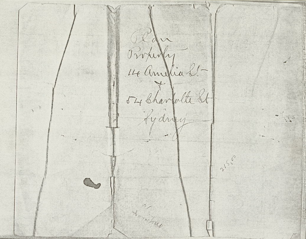
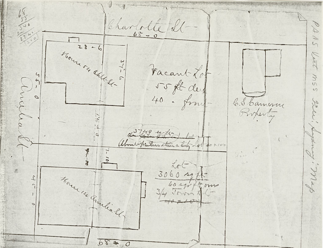
"Plan Property 14 Amelia St & 54
Charlotte St Sydney"
Reference: Nova Scotia Archives Map Collection: F/240
[PANS Vertical M55 File Sydney Map]
https://archives.novascotia.ca/maps/archives/?ID=1215
NOTE: 1915 - C. S. Cameron, 62 Charlotte Street - http://data2.archives.ca/e/e444/e011089530.pdf
------------------------------------------------------
"Plan Property 14 Amelia St & 54
Charlotte St Sydney"
Reference: Nova Scotia Archives Map Collection: F/240
[PANS Vertical M55 File Sydney Map]
https://archives.novascotia.ca/images/map/202015066.jpg
NOTE: 1915 - C. S. Cameron, 62 Charlotte Street - http://data2.archives.ca/e/e444/e011089530.pdf
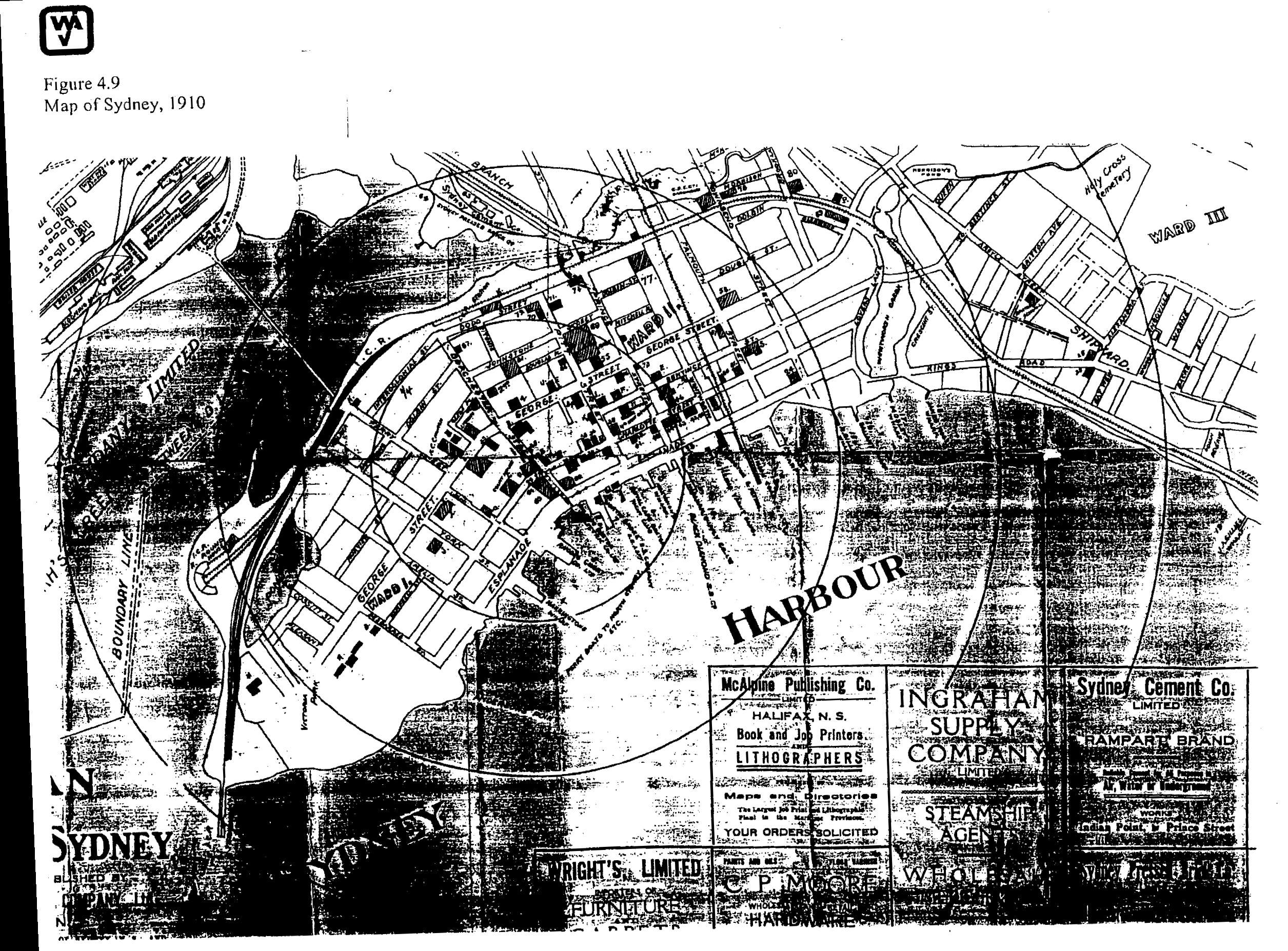
1934
AUGUST
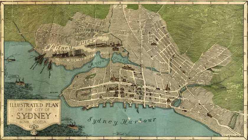
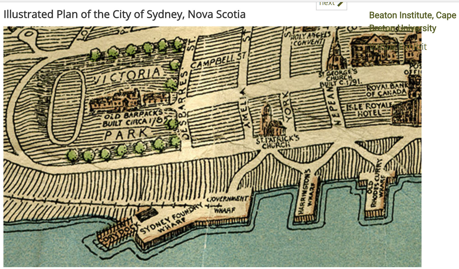
Arthur N. Wallace
"ILLUSTRATED PLAN OF THE CITY OF . SYDNEY . NOVA SCOTIA
Beaton Institute - Map 216
https://beatoninstitute.com/illustrated-plan-of-city-of-sydney-nova-scotia
https://novascotia.ca/archives/communityalbums/CapeBreton/archives.asp?ID=741&Language=
1952 - 1957
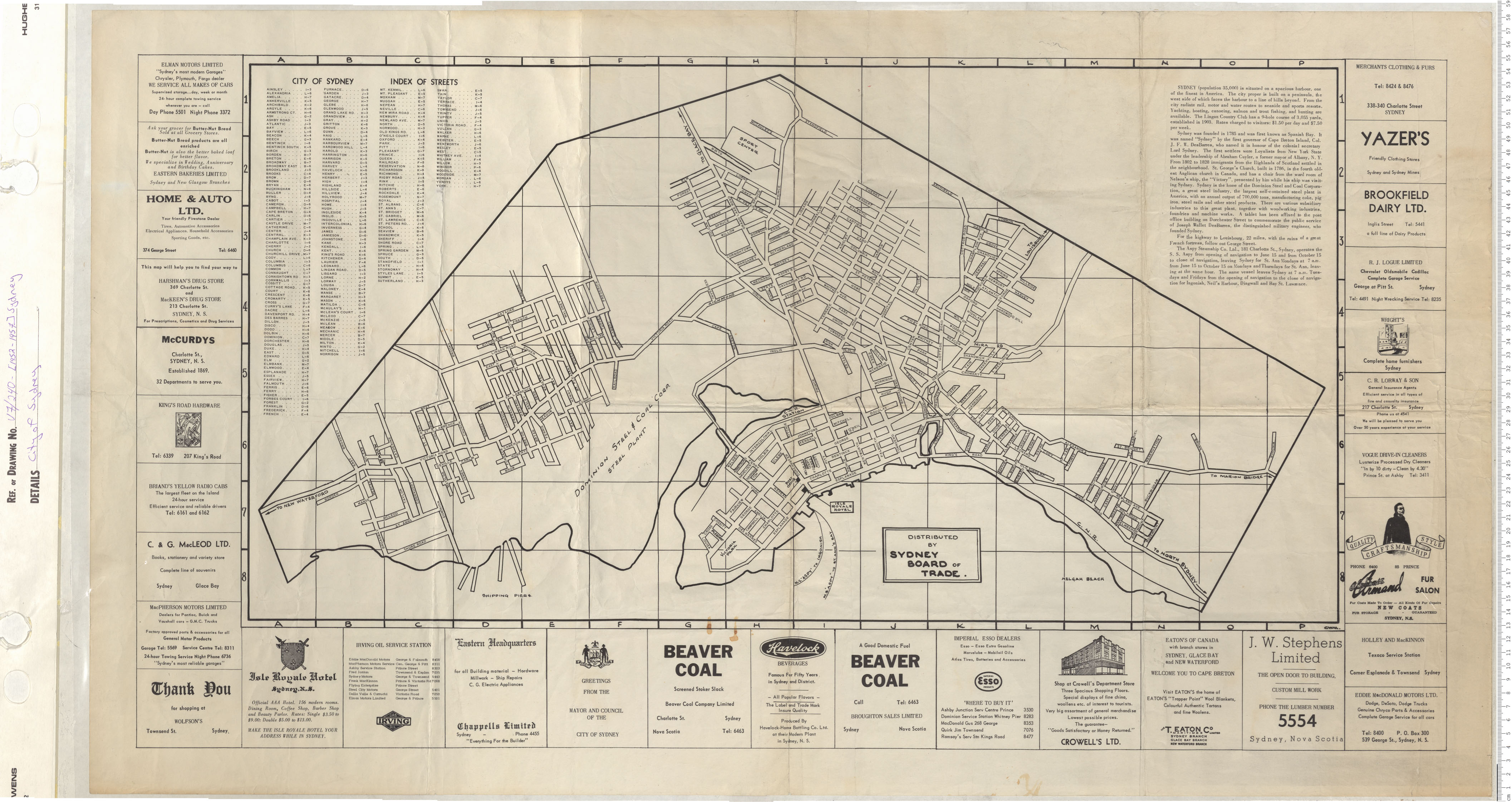
"CITY OF SYDNEY"
"INDEX OF STREETS"
City of Sydney Date: 1952 - 1957 Reference: Nova Scotia Archives Map Collection: V7 240 Sydney, Nova Scotia


_Sydney_Harbour,_Published_1851.jpg)