Parks
Website Design and Content
© by Eric Krause, Krause
House Info-Research Solutions (©
1996)
All Images
© Parks Canada Unless Otherwise Designated
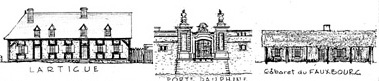
Researching the Fortress of Louisbourg National Historic Site of Canada
Recherche sur la Forteresse-de-Louisbourg Lieu historique national du
Canada
Parks
Canada ~ Parcs Canada
Cape Breton ~ Le
Cap-Breton
THIS RESEARCH AND GENEALOGICAL WEBSITE WAS ARCHIVED IN 2010
In the 1630s, enterprising merchants from La Rochelle in France built a small fortified settlement, called Saint Pierre, on a narrow isthmus of land separating the Atlantic Ocean from Bras d'Or Lake. Nicholas Denys, another merchant from La Rochelle, took possession of this settlement in 1650. The area had long been travelled by the Micmac people who portaged their canoes across the isthmus. Anxious to set up a fur trading operation, Denys encouraged the Micmacs to bring their furs in exchange for European goods. The old portage trail became a "haulover" road where oxen, or people, could pull Deny's ships from one shore to the other.
During the winter of 1668/69 a disastrous fire destroyed all of Denys's buildings and
Saint Pierre. No new development occurred until 1713 when the French moved Acadian
colonists to Cape Breton 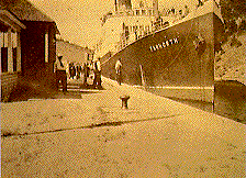 following the loss
of mainland Nova Scotia to the British. One of their new settlements, Port Toulouse, was
built close to the location of Denys's 17th century community. Port Toulouse soon became a
major supply centre for Louisbourg, 120 km to the north. To protect the new settlement and
transportation across the isthmus, the French built a fort on the shore. Both the fort and
the settlement were destroyed by the British in 1758 after their capture of Louisbourg.
following the loss
of mainland Nova Scotia to the British. One of their new settlements, Port Toulouse, was
built close to the location of Denys's 17th century community. Port Toulouse soon became a
major supply centre for Louisbourg, 120 km to the north. To protect the new settlement and
transportation across the isthmus, the French built a fort on the shore. Both the fort and
the settlement were destroyed by the British in 1758 after their capture of Louisbourg.
People from Great Britain moved into the area soon after, and a prominent Irish merchant, Lawrence Kavanagh Jr., established himself close to the ruins of Port Toulouse. In 1793, as revolutionary France declared war on Great Britain, the British built Fort Dorchester on the summit of Mount Granville, the highest spot in the region.
When the present village of St. Peters was founded early in the 19th century the new residents used Denys's old "haulover" road. They laid down skids so that ships could once again be hauled across the isthmus to the inland waterway, a shorter and more protected route to the growing settlements around Sydney.
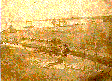
With a steadily increasing volume of shipping, plans were soon made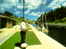 to replace the old portage road with a navigation
channel. The first study of its feasibility was commissioned in 1825, and work on the
canal began in 1854. A passage about 800m long was cut through the narrowest point of
land. After 15 years of digging, blasting, and drilling, an opening averaging 30m wide had
been cut through a solid granite hill 20m high. This passage was shored up with timbers
and planking. Locks were then installed, and in 1869 the canal finally became a reality.
Additions and renovations, widening the channel and lengthening the locks, continued until
1917. In 1985 Parks Canada completed a major project to restore both the Bras d'Or Lake
and the Atlantic Ocean entrance to the canal.
to replace the old portage road with a navigation
channel. The first study of its feasibility was commissioned in 1825, and work on the
canal began in 1854. A passage about 800m long was cut through the narrowest point of
land. After 15 years of digging, blasting, and drilling, an opening averaging 30m wide had
been cut through a solid granite hill 20m high. This passage was shored up with timbers
and planking. Locks were then installed, and in 1869 the canal finally became a reality.
Additions and renovations, widening the channel and lengthening the locks, continued until
1917. In 1985 Parks Canada completed a major project to restore both the Bras d'Or Lake
and the Atlantic Ocean entrance to the canal.
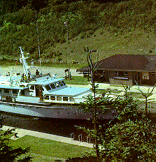
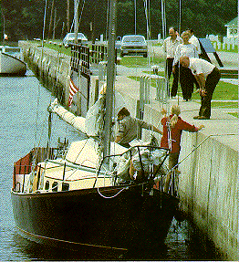
All kinds of pleasure craft now use the canal during the summer:canoes, schooners, and power cruisers. Only occasionally does a commercial vessel pass through these locks that once were so vital to communication and the economy of Cape Breton Island.
 There is tidal activity at both ends of the canal,
and there can be a difference of up to 1.4m between the water level of the lake and ocean.
For this reason, both entrances have double lock gates. The lock is 91.44m long by 14.45m
wide and can handle vessels with a 4.88m draught.
There is tidal activity at both ends of the canal,
and there can be a difference of up to 1.4m between the water level of the lake and ocean.
For this reason, both entrances have double lock gates. The lock is 91.44m long by 14.45m
wide and can handle vessels with a 4.88m draught.
The canal is open from mid-May to mid-October. There are picnic tables and a small interpretive exhibit at the site. The only surviving structure from the 19th century is the lockmaster's house which dates from 1876. Nicholas Denys's Fort Saint Pierre lies buried in the garden of this house. To the east, the ruins of Fort Dorchester high atop Mount Granville overlook the approaches to the canal. Artifacs unearthed during archaeological work on the Nicholas Denys settlement and nearby Port Toulouse show the importance and sophistication of these early European sites.
National Parks
 For scenery and history, Cape Breton is hard to
equal. Visitors can explore 18th century New France at the Fortress of Louisbourg
near Sydney or discover the many interests of Alexander Graham Bell at the museum
in Baddeck. Follow the world famous Cabot Trail around Cape Breton Highlands National
Park and see some of Nova Scotia's most spectacular scenery.
For scenery and history, Cape Breton is hard to
equal. Visitors can explore 18th century New France at the Fortress of Louisbourg
near Sydney or discover the many interests of Alexander Graham Bell at the museum
in Baddeck. Follow the world famous Cabot Trail around Cape Breton Highlands National
Park and see some of Nova Scotia's most spectacular scenery.
Provincial Park
Battery Provincial Park, adjacent to the canal, is open for camping and picnicking from mid-May to Labour Day. Water hook-ups are available. The sparse ruins of Port Toulouse and the more substantial ones of Fort Dorchester and the Kavanagh establishment can be visited.
Nicholas Denys Museum
This small community museum is located within a short walking distance of St. Peters Canal and contains a photographic history of the canal construction as well as antiques from the local area. A small admission fee is charged.
FEES/HOURS OF OPERATION/HOW TO GET THERE (External Link)
![]()
(louisbourg.info@pc.gc.ca)
St. Peters Canal
National Historic Site of Canada
c/o Fortress of Louisbourg
National Historic Site of Canada
259 Park Service Road
Louisbourg, Nova Scotia
B1C 2L2
(902) 733-2280
EXTERNAL LINKS
![]()